You are here: Home > Network List > NN - Western Great Basin/Eastern Sierra Nevada Stations List
> Station MCM07 Monte Cristo Menlo 07 > Earthquake Result Viewer
MCM07 Monte Cristo Menlo 07 - Earthquake Result Viewer
| Earthquake location: |
Leeward Islands |
| Earthquake latitude/longitude: |
16.7/-60.8 |
| Earthquake time(UTC): |
2021/03/26 (085) 04:51:39 GMT |
| Earthquake Depth: |
26 km |
| Earthquake Magnitude: |
5.8 mww |
| Earthquake Catalog/Contributor: |
NEIC PDE/us |
|
| Network: |
NN Western Great Basin/Eastern Sierra Nevada |
| Station: |
MCM07 Monte Cristo Menlo 07 |
| Lat/Lon: |
38.23 N/117.75 W |
| Elevation: |
1716 m |
|
| Distance: |
54.0 deg |
| Az: |
305.341 deg |
| Baz: |
96.928 deg |
| Ray Param: |
0.0656801 |
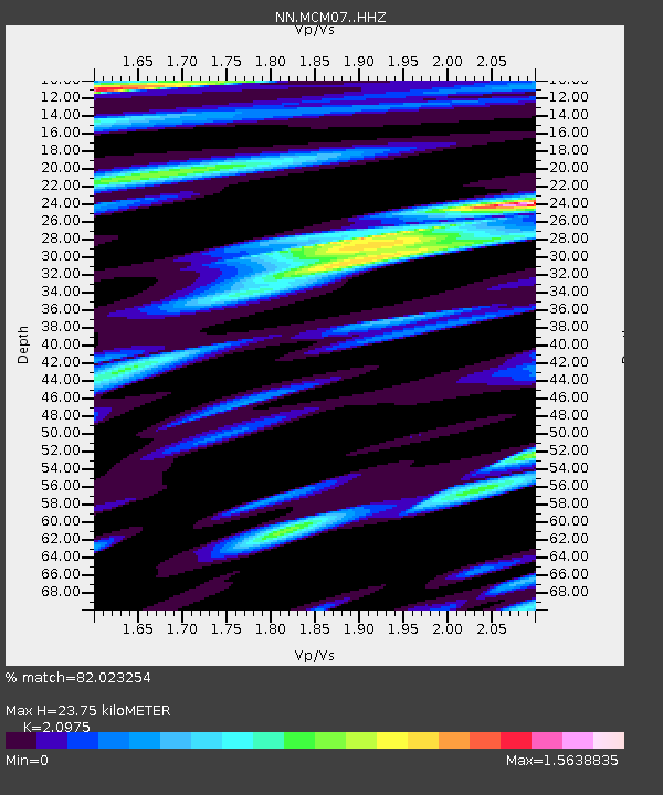
| Estimated Moho Depth: |
23.75 km |
| Estimated Crust Vp/Vs: |
2.10 |
| Assumed Crust Vp: |
6.276 km/s |
| Estimated Crust Vs: |
2.992 km/s |
| Estimated Crust Poisson's Ratio: |
0.35 |
|
| Radial Match: |
82.023254 % |
| Radial Bump: |
400 |
| Transverse Match: |
77.280106 % |
| Transverse Bump: |
400 |
| SOD ConfigId: |
24334971 |
| Insert Time: |
2021-04-09 05:13:11.426 +0000 |
| GWidth: |
2.5 |
| Max Bumps: |
400 |
| Tol: |
0.001 |
|

Signal To Noise
| Channel | StoN | STA | LTA |
| NN:MCM07: :HHZ:20210326T05:00:30.755008Z | 13.878735 | 1.9827771E-6 | 1.428644E-7 |
| NN:MCM07: :HHN:20210326T05:00:30.755008Z | 0.8894564 | 2.2752222E-7 | 2.557992E-7 |
| NN:MCM07: :HHE:20210326T05:00:30.755008Z | 2.632141 | 6.296804E-7 | 2.3922746E-7 |
| Arrivals |
| Ps | 4.3 SECOND |
| PpPs | 11 SECOND |
| PsPs/PpSs | 16 SECOND |


