You are here: Home > Network List > NX - Nanometrics Research Network Stations List
> Station WTX28 Z > Earthquake Result Viewer
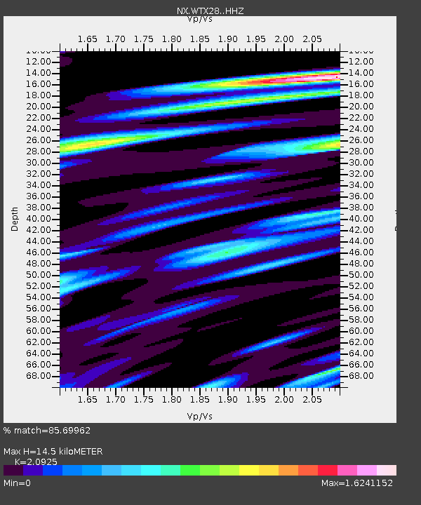
WTX28 Z - Earthquake Result Viewer
| Earthquake location: |
Leeward Islands |
| Earthquake latitude/longitude: |
16.7/-60.8 |
| Earthquake time(UTC): |
2021/03/26 (085) 04:51:39 GMT |
| Earthquake Depth: |
26 km |
| Earthquake Magnitude: |
5.8 mww |
| Earthquake Catalog/Contributor: |
NEIC PDE/us |
|
| Network: |
NX Nanometrics Research Network |
| Station: |
WTX28 Z |
| Lat/Lon: |
32.88 N/103.38 W |
| Elevation: |
1173 m |
|
| Distance: |
41.6 deg |
| Az: |
300.929 deg |
| Baz: |
102.301 deg |
| Ray Param: |
0.07366542 |
| Estimated Moho Depth: |
14.5 km |
| Estimated Crust Vp/Vs: |
2.09 |
| Assumed Crust Vp: |
6.129 km/s |
| Estimated Crust Vs: |
2.929 km/s |
| Estimated Crust Poisson's Ratio: |
0.35 |
|
| Radial Match: |
85.69962 % |
| Radial Bump: |
295 |
| Transverse Match: |
55.07479 % |
| Transverse Bump: |
400 |
| SOD ConfigId: |
24334971 |
| Insert Time: |
2021-04-09 05:13:36.469 +0000 |
| GWidth: |
2.5 |
| Max Bumps: |
400 |
| Tol: |
0.001 |
|

Signal To Noise
| Channel | StoN | STA | LTA |
| NX:WTX28: :HHZ:20210326T04:58:54.514987Z | 12.118318 | 9.26439E-7 | 7.644947E-8 |
| NX:WTX28: :HHN:20210326T04:58:54.514987Z | 1.6433086 | 2.0948113E-7 | 1.2747522E-7 |
| NX:WTX28: :HHE:20210326T04:58:54.514987Z | 6.3364553 | 7.7961573E-7 | 1.2303657E-7 |
| Arrivals |
| Ps | 2.7 SECOND |
| PpPs | 6.9 SECOND |
| PsPs/PpSs | 9.7 SECOND |


