You are here: Home > Network List > O2 - Oklahoma Consolidated Temporary Seismic Networks Stations List
> Station CRES Cresent, Oklahoma, USA > Earthquake Result Viewer
CRES Cresent, Oklahoma, USA - Earthquake Result Viewer
| Earthquake location: |
Leeward Islands |
| Earthquake latitude/longitude: |
16.7/-60.8 |
| Earthquake time(UTC): |
2021/03/26 (085) 04:51:39 GMT |
| Earthquake Depth: |
26 km |
| Earthquake Magnitude: |
5.8 mww |
| Earthquake Catalog/Contributor: |
NEIC PDE/us |
|
| Network: |
O2 Oklahoma Consolidated Temporary Seismic Networks |
| Station: |
CRES Cresent, Oklahoma, USA |
| Lat/Lon: |
36.04 N/97.53 W |
| Elevation: |
311 m |
|
| Distance: |
37.8 deg |
| Az: |
307.811 deg |
| Baz: |
110.896 deg |
| Ray Param: |
0.07587023 |
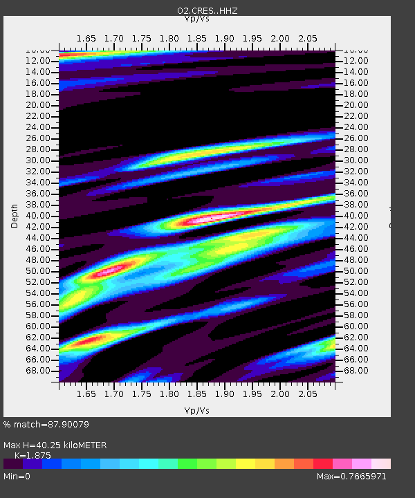
| Estimated Moho Depth: |
40.25 km |
| Estimated Crust Vp/Vs: |
1.88 |
| Assumed Crust Vp: |
6.483 km/s |
| Estimated Crust Vs: |
3.457 km/s |
| Estimated Crust Poisson's Ratio: |
0.30 |
|
| Radial Match: |
87.90079 % |
| Radial Bump: |
322 |
| Transverse Match: |
68.38897 % |
| Transverse Bump: |
400 |
| SOD ConfigId: |
24334971 |
| Insert Time: |
2021-04-09 05:13:49.566 +0000 |
| GWidth: |
2.5 |
| Max Bumps: |
400 |
| Tol: |
0.001 |
|

Signal To Noise
| Channel | StoN | STA | LTA |
| O2:CRES: :HHZ:20210326T04:58:23.514987Z | 17.747002 | 2.628387E-6 | 1.4810315E-7 |
| O2:CRES: :HHN:20210326T04:58:23.514987Z | 2.028966 | 3.790868E-7 | 1.8683743E-7 |
| O2:CRES: :HHE:20210326T04:58:23.514987Z | 9.767844 | 1.303627E-6 | 1.3346107E-7 |
| Arrivals |
| Ps | 5.8 SECOND |
| PpPs | 17 SECOND |
| PsPs/PpSs | 22 SECOND |


