You are here: Home > Network List > O2 - Oklahoma Consolidated Temporary Seismic Networks Stations List
> Station FW04 Hopeton, Oklahoma, USA > Earthquake Result Viewer
FW04 Hopeton, Oklahoma, USA - Earthquake Result Viewer
| Earthquake location: |
Leeward Islands |
| Earthquake latitude/longitude: |
16.7/-60.8 |
| Earthquake time(UTC): |
2021/03/26 (085) 04:51:39 GMT |
| Earthquake Depth: |
26 km |
| Earthquake Magnitude: |
5.8 mww |
| Earthquake Catalog/Contributor: |
NEIC PDE/us |
|
| Network: |
O2 Oklahoma Consolidated Temporary Seismic Networks |
| Station: |
FW04 Hopeton, Oklahoma, USA |
| Lat/Lon: |
36.60 N/98.67 W |
| Elevation: |
448 m |
|
| Distance: |
38.9 deg |
| Az: |
308.132 deg |
| Baz: |
110.481 deg |
| Ray Param: |
0.07528614 |
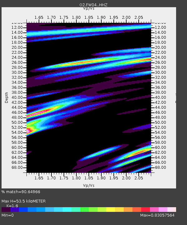
| Estimated Moho Depth: |
53.5 km |
| Estimated Crust Vp/Vs: |
1.60 |
| Assumed Crust Vp: |
6.426 km/s |
| Estimated Crust Vs: |
4.016 km/s |
| Estimated Crust Poisson's Ratio: |
0.18 |
|
| Radial Match: |
90.64966 % |
| Radial Bump: |
400 |
| Transverse Match: |
60.85164 % |
| Transverse Bump: |
400 |
| SOD ConfigId: |
24334971 |
| Insert Time: |
2021-04-09 05:14:03.441 +0000 |
| GWidth: |
2.5 |
| Max Bumps: |
400 |
| Tol: |
0.001 |
|

Signal To Noise
| Channel | StoN | STA | LTA |
| O2:FW04: :HHZ:20210326T04:58:32.334994Z | 13.54111 | 1.3285468E-6 | 9.81121E-8 |
| O2:FW04: :HHN:20210326T04:58:32.334994Z | 3.9762812 | 7.243236E-7 | 1.8216106E-7 |
| O2:FW04: :HHE:20210326T04:58:32.334994Z | 6.7468705 | 1.143627E-6 | 1.6950482E-7 |
| Arrivals |
| Ps | 5.4 SECOND |
| PpPs | 20 SECOND |
| PsPs/PpSs | 25 SECOND |


