You are here: Home > Network List > O2 - Oklahoma Consolidated Temporary Seismic Networks Stations List
> Station PERK Perkins, Oklahoma, USA > Earthquake Result Viewer
PERK Perkins, Oklahoma, USA - Earthquake Result Viewer
| Earthquake location: |
Leeward Islands |
| Earthquake latitude/longitude: |
16.7/-60.8 |
| Earthquake time(UTC): |
2021/03/26 (085) 04:51:39 GMT |
| Earthquake Depth: |
26 km |
| Earthquake Magnitude: |
5.8 mww |
| Earthquake Catalog/Contributor: |
NEIC PDE/us |
|
| Network: |
O2 Oklahoma Consolidated Temporary Seismic Networks |
| Station: |
PERK Perkins, Oklahoma, USA |
| Lat/Lon: |
35.93 N/97.13 W |
| Elevation: |
288 m |
|
| Distance: |
37.5 deg |
| Az: |
307.835 deg |
| Baz: |
111.151 deg |
| Ray Param: |
0.07606934 |
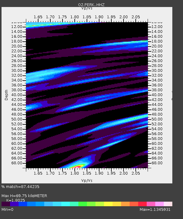
| Estimated Moho Depth: |
69.75 km |
| Estimated Crust Vp/Vs: |
1.80 |
| Assumed Crust Vp: |
6.426 km/s |
| Estimated Crust Vs: |
3.565 km/s |
| Estimated Crust Poisson's Ratio: |
0.28 |
|
| Radial Match: |
87.44235 % |
| Radial Bump: |
304 |
| Transverse Match: |
62.139484 % |
| Transverse Bump: |
367 |
| SOD ConfigId: |
24334971 |
| Insert Time: |
2021-04-09 05:14:18.426 +0000 |
| GWidth: |
2.5 |
| Max Bumps: |
400 |
| Tol: |
0.001 |
|

Signal To Noise
| Channel | StoN | STA | LTA |
| O2:PERK: :HHZ:20210326T04:58:20.584994Z | 17.273298 | 2.1732112E-6 | 1.2581334E-7 |
| O2:PERK: :HHN:20210326T04:58:20.584994Z | 2.483803 | 3.7155706E-7 | 1.49592E-7 |
| O2:PERK: :HHE:20210326T04:58:20.584994Z | 10.424654 | 1.219544E-6 | 1.1698651E-7 |
| Arrivals |
| Ps | 9.4 SECOND |
| PpPs | 28 SECOND |
| PsPs/PpSs | 38 SECOND |


