You are here: Home > Network List > O2 - Oklahoma Consolidated Temporary Seismic Networks Stations List
> Station SC16 Oakwood, Oklahoma, USA > Earthquake Result Viewer
SC16 Oakwood, Oklahoma, USA - Earthquake Result Viewer
| Earthquake location: |
Leeward Islands |
| Earthquake latitude/longitude: |
16.7/-60.8 |
| Earthquake time(UTC): |
2021/03/26 (085) 04:51:39 GMT |
| Earthquake Depth: |
26 km |
| Earthquake Magnitude: |
5.8 mww |
| Earthquake Catalog/Contributor: |
NEIC PDE/us |
|
| Network: |
O2 Oklahoma Consolidated Temporary Seismic Networks |
| Station: |
SC16 Oakwood, Oklahoma, USA |
| Lat/Lon: |
35.97 N/98.82 W |
| Elevation: |
500 m |
|
| Distance: |
38.8 deg |
| Az: |
307.137 deg |
| Baz: |
109.617 deg |
| Ray Param: |
0.075344585 |
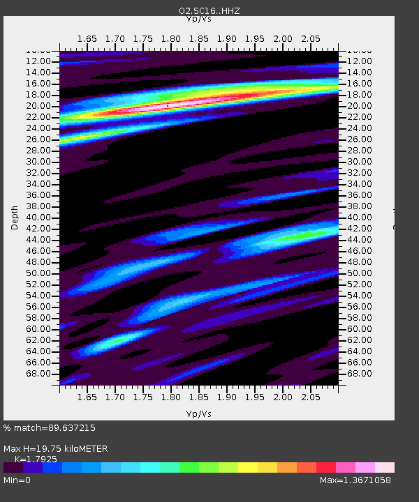
| Estimated Moho Depth: |
19.75 km |
| Estimated Crust Vp/Vs: |
1.79 |
| Assumed Crust Vp: |
6.315 km/s |
| Estimated Crust Vs: |
3.523 km/s |
| Estimated Crust Poisson's Ratio: |
0.27 |
|
| Radial Match: |
89.637215 % |
| Radial Bump: |
326 |
| Transverse Match: |
70.36705 % |
| Transverse Bump: |
394 |
| SOD ConfigId: |
24334971 |
| Insert Time: |
2021-04-09 05:14:59.289 +0000 |
| GWidth: |
2.5 |
| Max Bumps: |
400 |
| Tol: |
0.001 |
|

Signal To Noise
| Channel | StoN | STA | LTA |
| O2:SC16: :HHZ:20210326T04:58:31.519992Z | 12.91922 | 2.4075391E-6 | 1.8635329E-7 |
| O2:SC16: :HHN:20210326T04:58:31.519992Z | 4.355291 | 6.22717E-7 | 1.4297942E-7 |
| O2:SC16: :HHE:20210326T04:58:31.519992Z | 5.74865 | 9.543045E-7 | 1.6600497E-7 |
| Arrivals |
| Ps | 2.7 SECOND |
| PpPs | 8.2 SECOND |
| PsPs/PpSs | 11 SECOND |


