You are here: Home > Network List > TX - Texas Seismological Network Stations List
> Station WTFS Witchita Falls > Earthquake Result Viewer
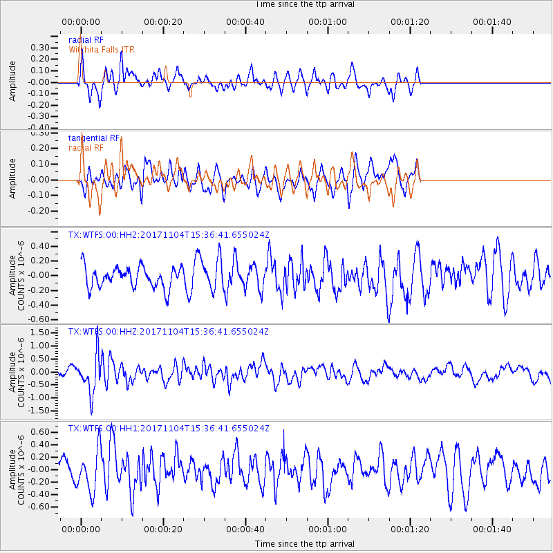
WTFS Witchita Falls - Earthquake Result Viewer
*The percent match for this event was below the threshold and hence no stack was calculated.
| Earthquake location: |
Tonga Islands |
| Earthquake latitude/longitude: |
-15.2/-173.3 |
| Earthquake time(UTC): |
2017/11/04 (308) 15:24:31 GMT |
| Earthquake Depth: |
10 km |
| Earthquake Magnitude: |
5.6 mb |
| Earthquake Catalog/Contributor: |
NEIC PDE/us |
|
| Network: |
TX Texas Seismological Network |
| Station: |
WTFS Witchita Falls |
| Lat/Lon: |
33.77 N/98.46 W |
| Elevation: |
277 m |
|
| Distance: |
86.2 deg |
| Az: |
53.698 deg |
| Baz: |
249.084 deg |
| Ray Param: |
$rayparam |
*The percent match for this event was below the threshold and hence was not used in the summary stack. |
|
| Radial Match: |
48.420303 % |
| Radial Bump: |
400 |
| Transverse Match: |
43.31977 % |
| Transverse Bump: |
400 |
| SOD ConfigId: |
2429771 |
| Insert Time: |
2017-11-18 15:29:01.607 +0000 |
| GWidth: |
2.5 |
| Max Bumps: |
400 |
| Tol: |
0.001 |
|
Signal To Noise
| Channel | StoN | STA | LTA |
| TX:WTFS:00:HHZ:20171104T15:36:41.655024Z | 3.5985408 | 7.219664E-7 | 2.0062754E-7 |
| TX:WTFS:00:HH1:20171104T15:36:41.655024Z | 1.5482706 | 3.42361E-7 | 2.2112478E-7 |
| TX:WTFS:00:HH2:20171104T15:36:41.655024Z | 1.5720497 | 2.1852965E-7 | 1.3900937E-7 |
| Arrivals |
| Ps | |
| PpPs | |
| PsPs/PpSs | |


