KASH XW.KASH - Earthquake Result Viewer
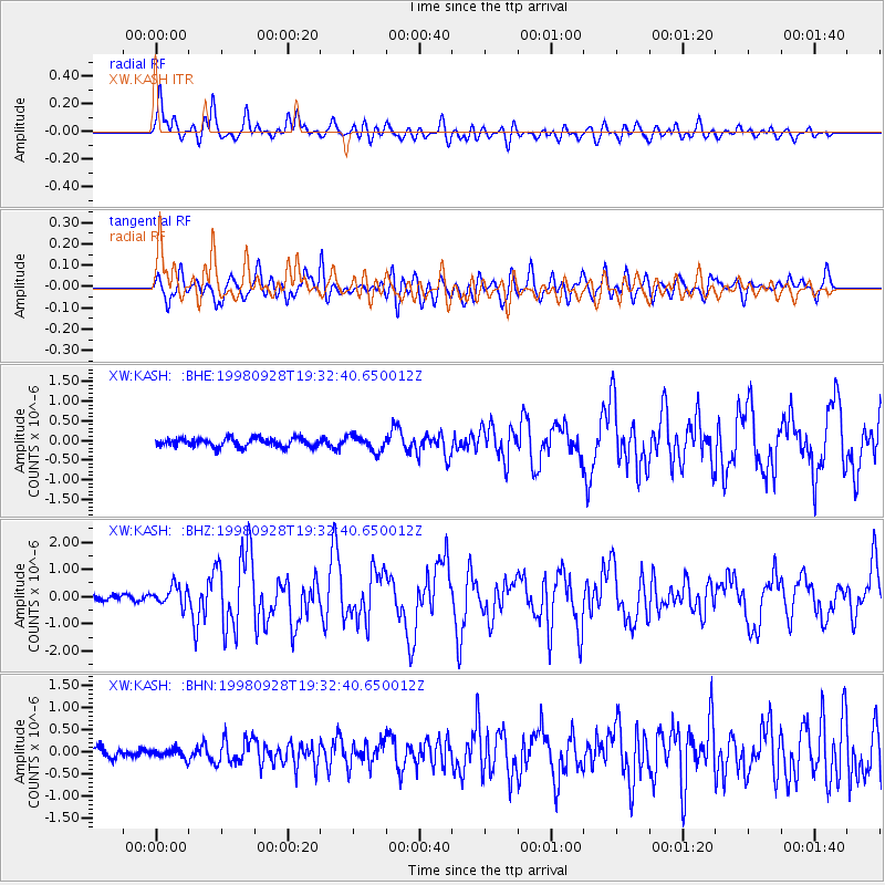
Earthquake location: Talaud Islands, Indonesia
Earthquake latitude/longitude: 3.8/126.4
Earthquake time(UTC): 1998/09/28 (271) 19:23:23 GMT
Earthquake Depth: 30 km
Earthquake Magnitude: 5.8 MB, 5.9 MS, 6.2 UNKNOWN, 6.1 MW
Earthquake Catalog/Contributor: WHDF/NEIC
Network: XW Tien Shan Continental Dynamics
Station: KASH XW.KASH
Lat/Lon: 39.52 N/75.92 E
Elevation: 1310 m
Distance: 57.8 deg
Az: 315.138 deg
Baz: 114.508 deg
Ray Param: 0.063228205
Estimated Moho Depth: 49.0 km
Estimated Crust Vp/Vs: 2.10
Assumed Crust Vp: 6.472 km/s
Estimated Crust Vs: 3.089 km/s
Estimated Crust Poisson's Ratio: 0.35
Radial Match: 88.14337 %
Radial Bump: 400
Transverse Match: 78.112526 %
Transverse Bump: 400
SOD ConfigId: 4480
Insert Time: 2010-02-26 15:27:45.632 +0000
GWidth: 2.5
Max Bumps: 400
Tol: 0.001

Signal To Noise

ChannelStoNSTALTA
XW:KASH: :BHZ:19980928T19:32:40.650012Z2.560793.5277623E-71.377607E-7
XW:KASH: :BHN:19980928T19:32:40.650012Z1.0431121.0497437E-71.0063576E-7
XW:KASH: :BHE:19980928T19:32:40.650012Z1.73585021.9599807E-71.12911856E-7
Arrivals
Ps8.6 SECOND
PpPs22 SECOND
PsPs/PpSs31 SECOND