You are here: Home > Network List > TA - USArray Transportable Network (new EarthScope stations) Stations List
> Station D27M Malcolm River, YT, CAN > Earthquake Result Viewer
D27M Malcolm River, YT, CAN - Earthquake Result Viewer
| Earthquake location: |
Leeward Islands |
| Earthquake latitude/longitude: |
16.7/-60.8 |
| Earthquake time(UTC): |
2021/03/26 (085) 04:51:39 GMT |
| Earthquake Depth: |
26 km |
| Earthquake Magnitude: |
5.8 mww |
| Earthquake Catalog/Contributor: |
NEIC PDE/us |
|
| Network: |
TA USArray Transportable Network (new EarthScope stations) |
| Station: |
D27M Malcolm River, YT, CAN |
| Lat/Lon: |
69.24 N/140.96 W |
| Elevation: |
896 m |
|
| Distance: |
71.0 deg |
| Az: |
338.198 deg |
| Baz: |
93.122 deg |
| Ray Param: |
0.054555528 |
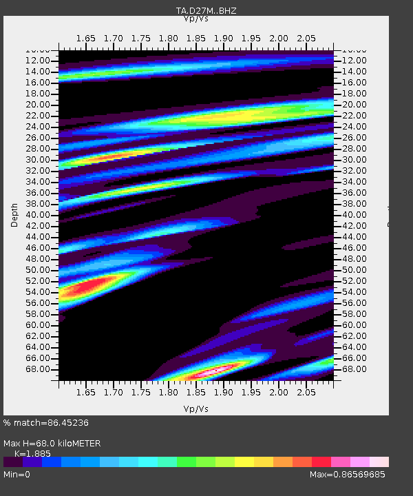
| Estimated Moho Depth: |
68.0 km |
| Estimated Crust Vp/Vs: |
1.88 |
| Assumed Crust Vp: |
6.522 km/s |
| Estimated Crust Vs: |
3.46 km/s |
| Estimated Crust Poisson's Ratio: |
0.30 |
|
| Radial Match: |
86.45236 % |
| Radial Bump: |
400 |
| Transverse Match: |
62.23044 % |
| Transverse Bump: |
400 |
| SOD ConfigId: |
24334971 |
| Insert Time: |
2021-04-09 05:17:59.372 +0000 |
| GWidth: |
2.5 |
| Max Bumps: |
400 |
| Tol: |
0.001 |
|

Signal To Noise
| Channel | StoN | STA | LTA |
| TA:D27M: :BHZ:20210326T05:02:24.250003Z | 6.9777675 | 5.2470216E-7 | 7.519628E-8 |
| TA:D27M: :BHN:20210326T05:02:24.250003Z | 1.3734688 | 7.860128E-8 | 5.72283E-8 |
| TA:D27M: :BHE:20210326T05:02:24.250003Z | 5.272112 | 2.441237E-7 | 4.6304724E-8 |
| Arrivals |
| Ps | 9.6 SECOND |
| PpPs | 29 SECOND |
| PsPs/PpSs | 39 SECOND |


