You are here: Home > Network List > TA - USArray Transportable Network (new EarthScope stations) Stations List
> Station F14K Arctic Creek, AK, USA > Earthquake Result Viewer
F14K Arctic Creek, AK, USA - Earthquake Result Viewer
| Earthquake location: |
Leeward Islands |
| Earthquake latitude/longitude: |
16.7/-60.8 |
| Earthquake time(UTC): |
2021/03/26 (085) 04:51:39 GMT |
| Earthquake Depth: |
26 km |
| Earthquake Magnitude: |
5.8 mww |
| Earthquake Catalog/Contributor: |
NEIC PDE/us |
|
| Network: |
TA USArray Transportable Network (new EarthScope stations) |
| Station: |
F14K Arctic Creek, AK, USA |
| Lat/Lon: |
65.47 N/166.33 W |
| Elevation: |
266 m |
|
| Distance: |
81.2 deg |
| Az: |
335.986 deg |
| Baz: |
69.135 deg |
| Ray Param: |
0.04769968 |
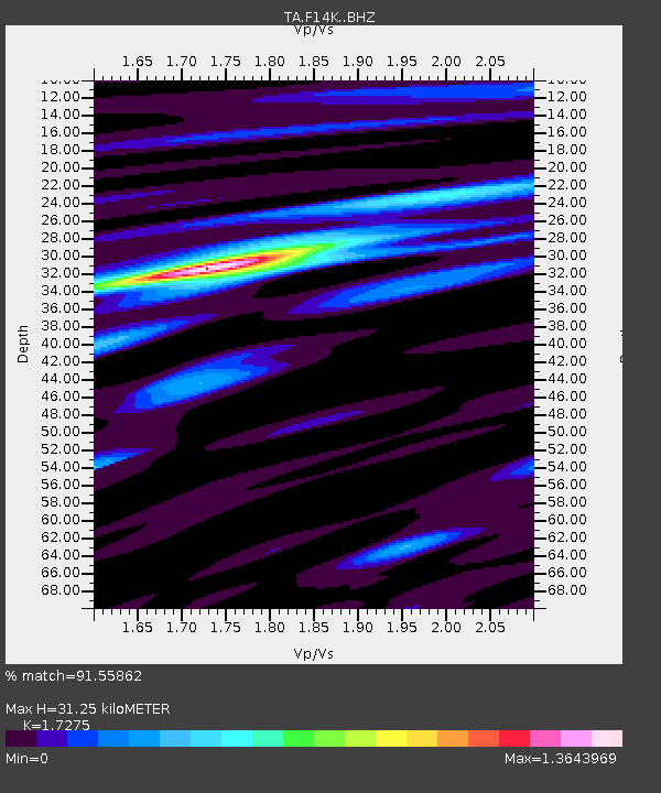
| Estimated Moho Depth: |
31.25 km |
| Estimated Crust Vp/Vs: |
1.73 |
| Assumed Crust Vp: |
6.307 km/s |
| Estimated Crust Vs: |
3.651 km/s |
| Estimated Crust Poisson's Ratio: |
0.25 |
|
| Radial Match: |
91.55862 % |
| Radial Bump: |
335 |
| Transverse Match: |
88.660645 % |
| Transverse Bump: |
400 |
| SOD ConfigId: |
24334971 |
| Insert Time: |
2021-04-09 05:18:10.628 +0000 |
| GWidth: |
2.5 |
| Max Bumps: |
400 |
| Tol: |
0.001 |
|
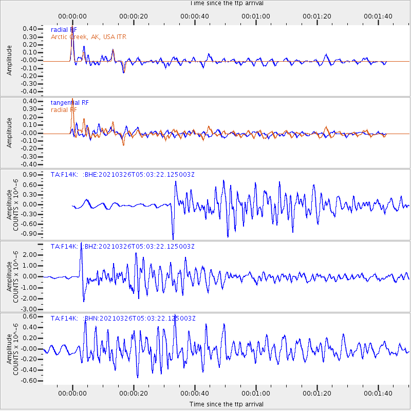
Signal To Noise
| Channel | StoN | STA | LTA |
| TA:F14K: :BHZ:20210326T05:03:22.125003Z | 10.55454 | 1.142191E-6 | 1.08217975E-7 |
| TA:F14K: :BHN:20210326T05:03:22.125003Z | 4.3130503 | 1.917388E-7 | 4.44555E-8 |
| TA:F14K: :BHE:20210326T05:03:22.125003Z | 6.202033 | 3.716169E-7 | 5.991856E-8 |
| Arrivals |
| Ps | 3.7 SECOND |
| PpPs | 13 SECOND |
| PsPs/PpSs | 17 SECOND |


