You are here: Home > Network List > TA - USArray Transportable Network (new EarthScope stations) Stations List
> Station G21K Allakaket, AK, USA > Earthquake Result Viewer
G21K Allakaket, AK, USA - Earthquake Result Viewer
| Earthquake location: |
Leeward Islands |
| Earthquake latitude/longitude: |
16.7/-60.8 |
| Earthquake time(UTC): |
2021/03/26 (085) 04:51:39 GMT |
| Earthquake Depth: |
26 km |
| Earthquake Magnitude: |
5.8 mww |
| Earthquake Catalog/Contributor: |
NEIC PDE/us |
|
| Network: |
TA USArray Transportable Network (new EarthScope stations) |
| Station: |
G21K Allakaket, AK, USA |
| Lat/Lon: |
66.52 N/153.51 W |
| Elevation: |
446 m |
|
| Distance: |
75.9 deg |
| Az: |
335.624 deg |
| Baz: |
80.773 deg |
| Ray Param: |
0.05131885 |
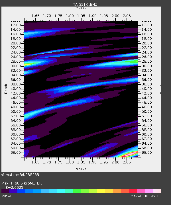
| Estimated Moho Depth: |
68.5 km |
| Estimated Crust Vp/Vs: |
2.06 |
| Assumed Crust Vp: |
6.455 km/s |
| Estimated Crust Vs: |
3.13 km/s |
| Estimated Crust Poisson's Ratio: |
0.35 |
|
| Radial Match: |
86.058235 % |
| Radial Bump: |
400 |
| Transverse Match: |
68.05294 % |
| Transverse Bump: |
365 |
| SOD ConfigId: |
24334971 |
| Insert Time: |
2021-04-09 05:18:29.938 +0000 |
| GWidth: |
2.5 |
| Max Bumps: |
400 |
| Tol: |
0.001 |
|

Signal To Noise
| Channel | StoN | STA | LTA |
| TA:G21K: :BHZ:20210326T05:02:52.875003Z | 16.32766 | 8.655161E-7 | 5.3009195E-8 |
| TA:G21K: :BHN:20210326T05:02:52.875003Z | 3.0098386 | 2.0099405E-7 | 6.6779016E-8 |
| TA:G21K: :BHE:20210326T05:02:52.875003Z | 3.2405329 | 3.2016652E-7 | 9.8800584E-8 |
| Arrivals |
| Ps | 12 SECOND |
| PpPs | 32 SECOND |
| PsPs/PpSs | 43 SECOND |


