You are here: Home > Network List > TA - USArray Transportable Network (new EarthScope stations) Stations List
> Station H31M Peel River, Yukon, CAN > Earthquake Result Viewer
H31M Peel River, Yukon, CAN - Earthquake Result Viewer
*The percent match for this event was below the threshold and hence no stack was calculated.
| Earthquake location: |
Leeward Islands |
| Earthquake latitude/longitude: |
16.7/-60.8 |
| Earthquake time(UTC): |
2021/03/26 (085) 04:51:39 GMT |
| Earthquake Depth: |
26 km |
| Earthquake Magnitude: |
5.8 mww |
| Earthquake Catalog/Contributor: |
NEIC PDE/us |
|
| Network: |
TA USArray Transportable Network (new EarthScope stations) |
| Station: |
H31M Peel River, Yukon, CAN |
| Lat/Lon: |
65.81 N/134.34 W |
| Elevation: |
642 m |
|
| Distance: |
68.2 deg |
| Az: |
334.801 deg |
| Baz: |
98.054 deg |
| Ray Param: |
$rayparam |
*The percent match for this event was below the threshold and hence was not used in the summary stack. |
|
| Radial Match: |
79.01969 % |
| Radial Bump: |
400 |
| Transverse Match: |
73.99332 % |
| Transverse Bump: |
400 |
| SOD ConfigId: |
24334971 |
| Insert Time: |
2021-04-09 05:18:43.207 +0000 |
| GWidth: |
2.5 |
| Max Bumps: |
400 |
| Tol: |
0.001 |
|
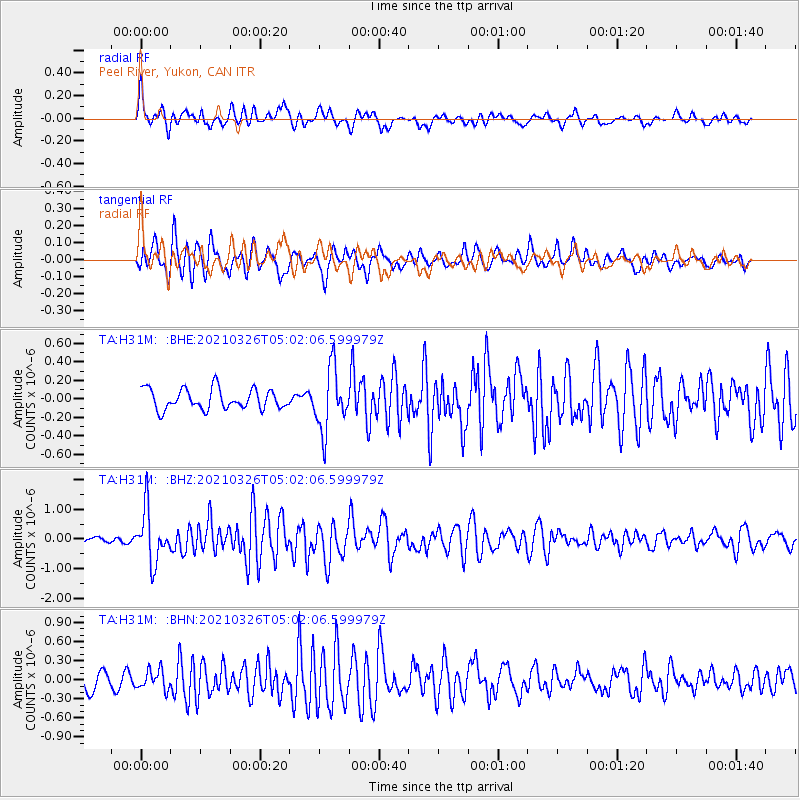
Signal To Noise
| Channel | StoN | STA | LTA |
| TA:H31M: :BHZ:20210326T05:02:06.599979Z | 9.132893 | 8.7257825E-7 | 9.5542376E-8 |
| TA:H31M: :BHN:20210326T05:02:06.599979Z | 1.1974419 | 1.5249637E-7 | 1.2735178E-7 |
| TA:H31M: :BHE:20210326T05:02:06.599979Z | 3.0724738 | 3.3482226E-7 | 1.0897482E-7 |
| Arrivals |
| Ps | |
| PpPs | |
| PsPs/PpSs | |


