You are here: Home > Network List > TA - USArray Transportable Network (new EarthScope stations) Stations List
> Station J14K Nanvaranak Lake, AK, USA > Earthquake Result Viewer
J14K Nanvaranak Lake, AK, USA - Earthquake Result Viewer
| Earthquake location: |
Leeward Islands |
| Earthquake latitude/longitude: |
16.7/-60.8 |
| Earthquake time(UTC): |
2021/03/26 (085) 04:51:39 GMT |
| Earthquake Depth: |
26 km |
| Earthquake Magnitude: |
5.8 mww |
| Earthquake Catalog/Contributor: |
NEIC PDE/us |
|
| Network: |
TA USArray Transportable Network (new EarthScope stations) |
| Station: |
J14K Nanvaranak Lake, AK, USA |
| Lat/Lon: |
62.75 N/163.55 W |
| Elevation: |
25 m |
|
| Distance: |
81.0 deg |
| Az: |
332.964 deg |
| Baz: |
71.163 deg |
| Ray Param: |
0.04784951 |
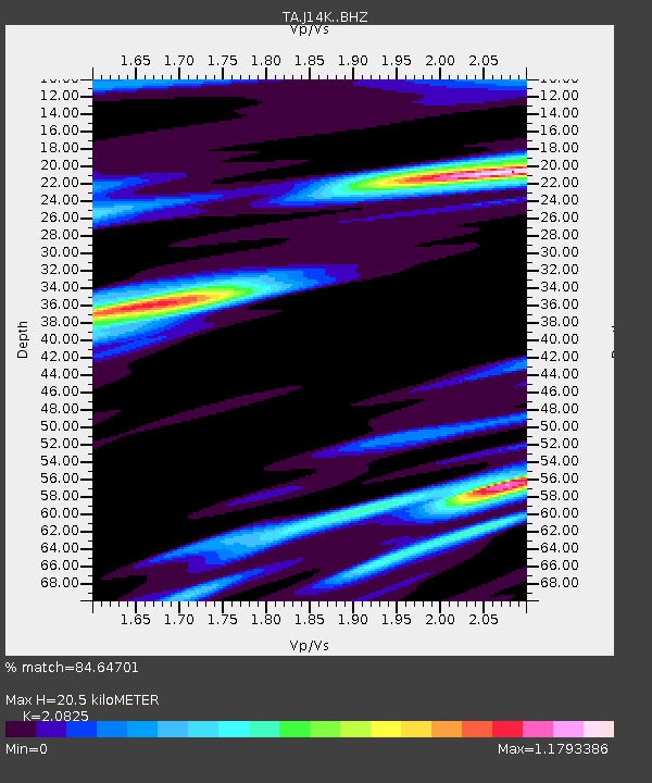
| Estimated Moho Depth: |
20.5 km |
| Estimated Crust Vp/Vs: |
2.08 |
| Assumed Crust Vp: |
6.155 km/s |
| Estimated Crust Vs: |
2.956 km/s |
| Estimated Crust Poisson's Ratio: |
0.35 |
|
| Radial Match: |
84.64701 % |
| Radial Bump: |
351 |
| Transverse Match: |
72.451706 % |
| Transverse Bump: |
381 |
| SOD ConfigId: |
24334971 |
| Insert Time: |
2021-04-09 05:18:51.435 +0000 |
| GWidth: |
2.5 |
| Max Bumps: |
400 |
| Tol: |
0.001 |
|

Signal To Noise
| Channel | StoN | STA | LTA |
| TA:J14K: :BHZ:20210326T05:03:20.974979Z | 8.697113 | 8.8843836E-7 | 1.0215325E-7 |
| TA:J14K: :BHN:20210326T05:03:20.974979Z | 1.5322614 | 1.976883E-7 | 1.2901735E-7 |
| TA:J14K: :BHE:20210326T05:03:20.974979Z | 3.5493913 | 3.026834E-7 | 8.527755E-8 |
| Arrivals |
| Ps | 3.7 SECOND |
| PpPs | 10 SECOND |
| PsPs/PpSs | 14 SECOND |


