You are here: Home > Network List > TA - USArray Transportable Network (new EarthScope stations) Stations List
> Station R33M Jennings River, BC, CAN > Earthquake Result Viewer
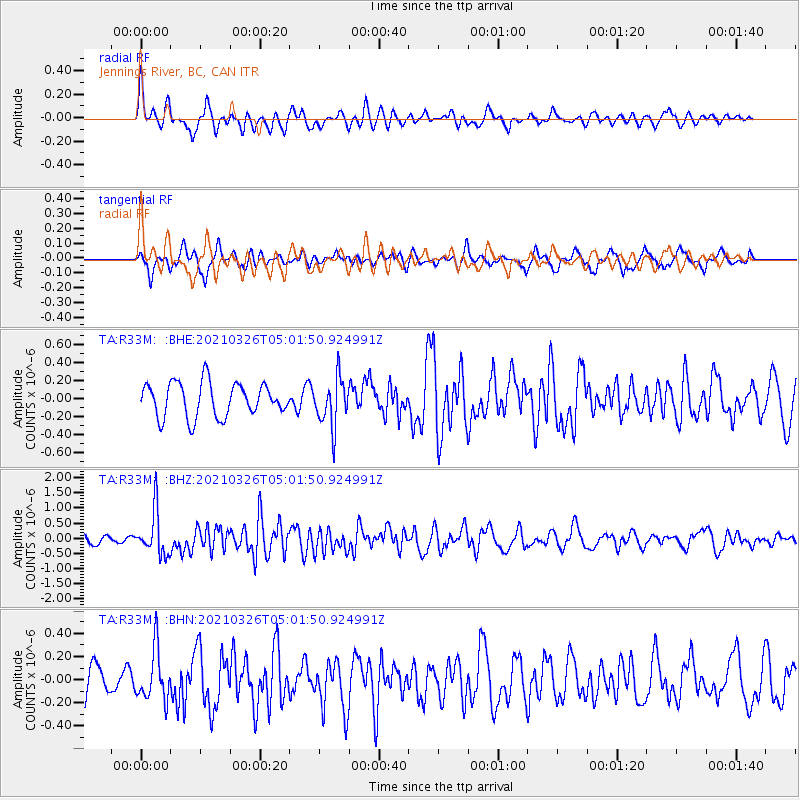
R33M Jennings River, BC, CAN - Earthquake Result Viewer
*The percent match for this event was below the threshold and hence no stack was calculated.
| Earthquake location: |
Leeward Islands |
| Earthquake latitude/longitude: |
16.7/-60.8 |
| Earthquake time(UTC): |
2021/03/26 (085) 04:51:39 GMT |
| Earthquake Depth: |
26 km |
| Earthquake Magnitude: |
5.8 mww |
| Earthquake Catalog/Contributor: |
NEIC PDE/us |
|
| Network: |
TA USArray Transportable Network (new EarthScope stations) |
| Station: |
R33M Jennings River, BC, CAN |
| Lat/Lon: |
59.39 N/130.97 W |
| Elevation: |
1437 m |
|
| Distance: |
65.7 deg |
| Az: |
328.125 deg |
| Baz: |
98.432 deg |
| Ray Param: |
$rayparam |
*The percent match for this event was below the threshold and hence was not used in the summary stack. |
|
| Radial Match: |
62.687996 % |
| Radial Bump: |
400 |
| Transverse Match: |
55.988796 % |
| Transverse Bump: |
358 |
| SOD ConfigId: |
24334971 |
| Insert Time: |
2021-04-09 05:19:33.677 +0000 |
| GWidth: |
2.5 |
| Max Bumps: |
400 |
| Tol: |
0.001 |
|
Signal To Noise
| Channel | StoN | STA | LTA |
| TA:R33M: :BHZ:20210326T05:01:50.924991Z | 5.743355 | 7.2937274E-7 | 1.269942E-7 |
| TA:R33M: :BHN:20210326T05:01:50.924991Z | 1.7655375 | 2.1936302E-7 | 1.2424715E-7 |
| TA:R33M: :BHE:20210326T05:01:50.924991Z | 1.422166 | 2.6765701E-7 | 1.8820377E-7 |
| Arrivals |
| Ps | |
| PpPs | |
| PsPs/PpSs | |


