You are here: Home > Network List > TX - Texas Seismological Network Stations List
> Station FW01 Dallas Executive Airport > Earthquake Result Viewer
FW01 Dallas Executive Airport - Earthquake Result Viewer
| Earthquake location: |
Leeward Islands |
| Earthquake latitude/longitude: |
16.7/-60.8 |
| Earthquake time(UTC): |
2021/03/26 (085) 04:51:39 GMT |
| Earthquake Depth: |
26 km |
| Earthquake Magnitude: |
5.8 mww |
| Earthquake Catalog/Contributor: |
NEIC PDE/us |
|
| Network: |
TX Texas Seismological Network |
| Station: |
FW01 Dallas Executive Airport |
| Lat/Lon: |
32.68 N/96.88 W |
| Elevation: |
203 m |
|
| Distance: |
36.2 deg |
| Az: |
302.857 deg |
| Baz: |
107.308 deg |
| Ray Param: |
0.07678507 |
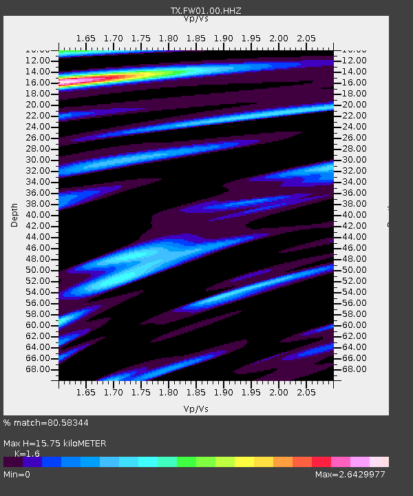
| Estimated Moho Depth: |
15.75 km |
| Estimated Crust Vp/Vs: |
1.60 |
| Assumed Crust Vp: |
6.38 km/s |
| Estimated Crust Vs: |
3.988 km/s |
| Estimated Crust Poisson's Ratio: |
0.18 |
|
| Radial Match: |
80.58344 % |
| Radial Bump: |
400 |
| Transverse Match: |
73.11002 % |
| Transverse Bump: |
400 |
| SOD ConfigId: |
24334971 |
| Insert Time: |
2021-04-09 05:20:06.877 +0000 |
| GWidth: |
2.5 |
| Max Bumps: |
400 |
| Tol: |
0.001 |
|
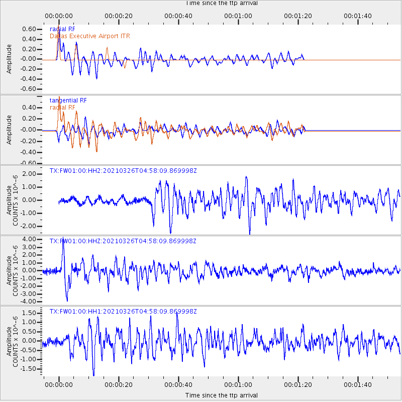
Signal To Noise
| Channel | StoN | STA | LTA |
| TX:FW01:00:HHZ:20210326T04:58:09.869998Z | 9.763146 | 1.8394818E-6 | 1.8841077E-7 |
| TX:FW01:00:HH1:20210326T04:58:09.869998Z | 2.201189 | 3.5612874E-7 | 1.6178925E-7 |
| TX:FW01:00:HH2:20210326T04:58:09.869998Z | 4.2821383 | 8.258555E-7 | 1.9286054E-7 |
| Arrivals |
| Ps | 1.6 SECOND |
| PpPs | 5.9 SECOND |
| PsPs/PpSs | 7.5 SECOND |


