You are here: Home > Network List > TX - Texas Seismological Network Stations List
> Station HNDO Hondo > Earthquake Result Viewer
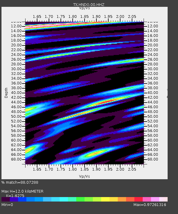
HNDO Hondo - Earthquake Result Viewer
| Earthquake location: |
Leeward Islands |
| Earthquake latitude/longitude: |
16.7/-60.8 |
| Earthquake time(UTC): |
2021/03/26 (085) 04:51:39 GMT |
| Earthquake Depth: |
26 km |
| Earthquake Magnitude: |
5.8 mww |
| Earthquake Catalog/Contributor: |
NEIC PDE/us |
|
| Network: |
TX Texas Seismological Network |
| Station: |
HNDO Hondo |
| Lat/Lon: |
29.53 N/99.28 W |
| Elevation: |
381 m |
|
| Distance: |
37.4 deg |
| Az: |
296.923 deg |
| Baz: |
101.321 deg |
| Ray Param: |
0.076094344 |
| Estimated Moho Depth: |
12.0 km |
| Estimated Crust Vp/Vs: |
1.63 |
| Assumed Crust Vp: |
6.347 km/s |
| Estimated Crust Vs: |
3.9 km/s |
| Estimated Crust Poisson's Ratio: |
0.20 |
|
| Radial Match: |
88.07288 % |
| Radial Bump: |
324 |
| Transverse Match: |
67.8202 % |
| Transverse Bump: |
400 |
| SOD ConfigId: |
24334971 |
| Insert Time: |
2021-04-09 05:20:20.417 +0000 |
| GWidth: |
2.5 |
| Max Bumps: |
400 |
| Tol: |
0.001 |
|

Signal To Noise
| Channel | StoN | STA | LTA |
| TX:HNDO:00:HHZ:20210326T04:58:20.230014Z | 18.12827 | 1.5103126E-6 | 8.3312564E-8 |
| TX:HNDO:00:HH1:20210326T04:58:20.230014Z | 6.7700915 | 4.954107E-7 | 7.3176366E-8 |
| TX:HNDO:00:HH2:20210326T04:58:20.230014Z | 7.6454697 | 7.588961E-7 | 9.926088E-8 |
| Arrivals |
| Ps | 1.3 SECOND |
| PpPs | 4.6 SECOND |
| PsPs/PpSs | 5.9 SECOND |


