You are here: Home > Network List > US - United States National Seismic Network Stations List
> Station EGMT Eagleton, Montana, USA > Earthquake Result Viewer
EGMT Eagleton, Montana, USA - Earthquake Result Viewer
*The percent match for this event was below the threshold and hence no stack was calculated.
| Earthquake location: |
Tonga Islands |
| Earthquake latitude/longitude: |
-15.2/-173.3 |
| Earthquake time(UTC): |
2017/11/04 (308) 15:24:31 GMT |
| Earthquake Depth: |
10 km |
| Earthquake Magnitude: |
5.6 mb |
| Earthquake Catalog/Contributor: |
NEIC PDE/us |
|
| Network: |
US United States National Seismic Network |
| Station: |
EGMT Eagleton, Montana, USA |
| Lat/Lon: |
48.02 N/109.75 W |
| Elevation: |
1055 m |
|
| Distance: |
84.5 deg |
| Az: |
37.153 deg |
| Baz: |
240.303 deg |
| Ray Param: |
$rayparam |
*The percent match for this event was below the threshold and hence was not used in the summary stack. |
|
| Radial Match: |
41.640247 % |
| Radial Bump: |
400 |
| Transverse Match: |
57.18244 % |
| Transverse Bump: |
400 |
| SOD ConfigId: |
2429771 |
| Insert Time: |
2017-11-18 15:29:46.344 +0000 |
| GWidth: |
2.5 |
| Max Bumps: |
400 |
| Tol: |
0.001 |
|
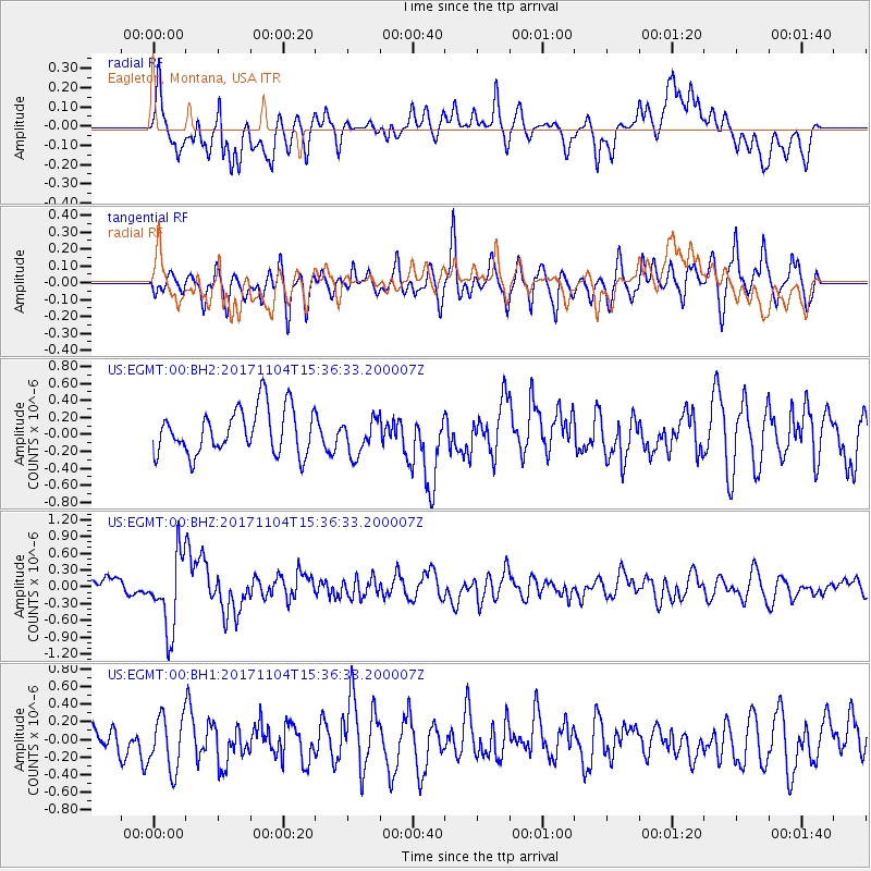
Signal To Noise
| Channel | StoN | STA | LTA |
| US:EGMT:00:BHZ:20171104T15:36:33.200007Z | 4.2188797 | 6.607562E-7 | 1.5661888E-7 |
| US:EGMT:00:BH1:20171104T15:36:33.200007Z | 1.6328406 | 3.0585466E-7 | 1.8731446E-7 |
| US:EGMT:00:BH2:20171104T15:36:33.200007Z | 0.79951304 | 2.1249181E-7 | 2.6577655E-7 |
| Arrivals |
| Ps | |
| PpPs | |
| PsPs/PpSs | |


