You are here: Home > Network List > TX - Texas Seismological Network Stations List
> Station SNAG San Augustine > Earthquake Result Viewer
SNAG San Augustine - Earthquake Result Viewer
| Earthquake location: |
Leeward Islands |
| Earthquake latitude/longitude: |
16.7/-60.8 |
| Earthquake time(UTC): |
2021/03/26 (085) 04:51:39 GMT |
| Earthquake Depth: |
26 km |
| Earthquake Magnitude: |
5.8 mww |
| Earthquake Catalog/Contributor: |
NEIC PDE/us |
|
| Network: |
TX Texas Seismological Network |
| Station: |
SNAG San Augustine |
| Lat/Lon: |
31.52 N/94.18 W |
| Elevation: |
84 m |
|
| Distance: |
33.7 deg |
| Az: |
302.143 deg |
| Baz: |
108.151 deg |
| Ray Param: |
0.078072265 |
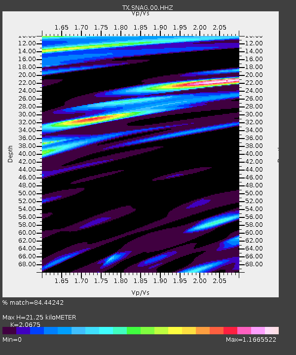
| Estimated Moho Depth: |
21.25 km |
| Estimated Crust Vp/Vs: |
2.07 |
| Assumed Crust Vp: |
5.738 km/s |
| Estimated Crust Vs: |
2.776 km/s |
| Estimated Crust Poisson's Ratio: |
0.35 |
|
| Radial Match: |
84.44242 % |
| Radial Bump: |
351 |
| Transverse Match: |
70.43675 % |
| Transverse Bump: |
400 |
| SOD ConfigId: |
24334971 |
| Insert Time: |
2021-04-09 05:21:23.292 +0000 |
| GWidth: |
2.5 |
| Max Bumps: |
400 |
| Tol: |
0.001 |
|
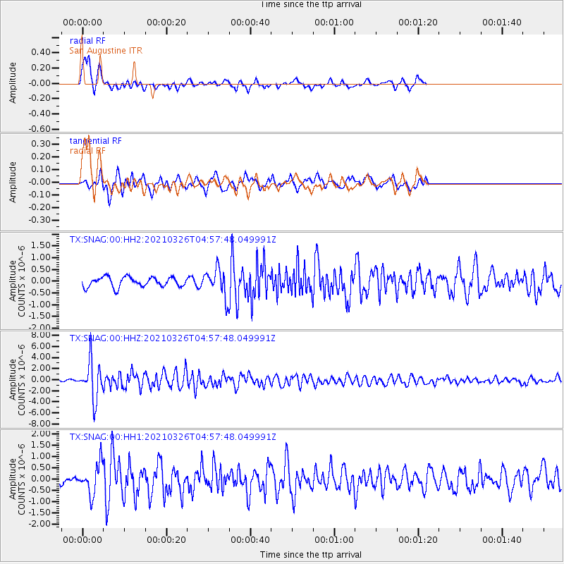
Signal To Noise
| Channel | StoN | STA | LTA |
| TX:SNAG:00:HHZ:20210326T04:57:48.049991Z | 22.163763 | 3.4746777E-6 | 1.5677291E-7 |
| TX:SNAG:00:HH1:20210326T04:57:48.049991Z | 3.6963348 | 6.9048474E-7 | 1.8680254E-7 |
| TX:SNAG:00:HH2:20210326T04:57:48.049991Z | 2.9151714 | 6.0316836E-7 | 2.0690665E-7 |
| Arrivals |
| Ps | 4.2 SECOND |
| PpPs | 11 SECOND |
| PsPs/PpSs | 15 SECOND |


