You are here: Home > Network List > TX - Texas Seismological Network Stations List
> Station VHRN Van Horn > Earthquake Result Viewer
VHRN Van Horn - Earthquake Result Viewer
| Earthquake location: |
Leeward Islands |
| Earthquake latitude/longitude: |
16.7/-60.8 |
| Earthquake time(UTC): |
2021/03/26 (085) 04:51:39 GMT |
| Earthquake Depth: |
26 km |
| Earthquake Magnitude: |
5.8 mww |
| Earthquake Catalog/Contributor: |
NEIC PDE/us |
|
| Network: |
TX Texas Seismological Network |
| Station: |
VHRN Van Horn |
| Lat/Lon: |
30.79 N/104.99 W |
| Elevation: |
1342 m |
|
| Distance: |
42.5 deg |
| Az: |
297.491 deg |
| Baz: |
98.904 deg |
| Ray Param: |
0.07308221 |
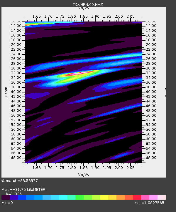
| Estimated Moho Depth: |
31.75 km |
| Estimated Crust Vp/Vs: |
1.84 |
| Assumed Crust Vp: |
6.361 km/s |
| Estimated Crust Vs: |
3.466 km/s |
| Estimated Crust Poisson's Ratio: |
0.29 |
|
| Radial Match: |
88.55577 % |
| Radial Bump: |
335 |
| Transverse Match: |
69.01284 % |
| Transverse Bump: |
400 |
| SOD ConfigId: |
24334971 |
| Insert Time: |
2021-04-09 05:21:23.689 +0000 |
| GWidth: |
2.5 |
| Max Bumps: |
400 |
| Tol: |
0.001 |
|

Signal To Noise
| Channel | StoN | STA | LTA |
| TX:VHRN:00:HHZ:20210326T04:59:02.359988Z | 10.869001 | 1.7607124E-6 | 1.6199395E-7 |
| TX:VHRN:00:HH1:20210326T04:59:02.359988Z | 3.7467716 | 4.374508E-7 | 1.16754066E-7 |
| TX:VHRN:00:HH2:20210326T04:59:02.359988Z | 9.855962 | 8.5245654E-7 | 8.649146E-8 |
| Arrivals |
| Ps | 4.4 SECOND |
| PpPs | 13 SECOND |
| PsPs/PpSs | 18 SECOND |


