You are here: Home > Network List > US - United States National Seismic Network Stations List
> Station WUAZ Wupatki, Arizona, USA > Earthquake Result Viewer
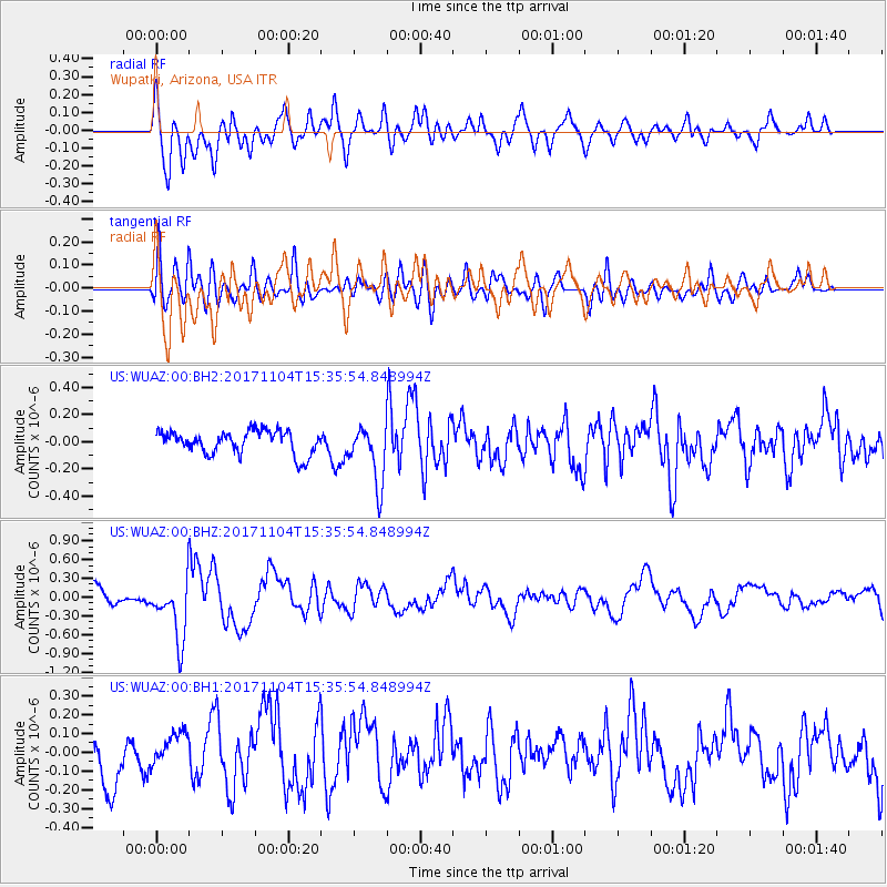
WUAZ Wupatki, Arizona, USA - Earthquake Result Viewer
*The percent match for this event was below the threshold and hence no stack was calculated.
| Earthquake location: |
Tonga Islands |
| Earthquake latitude/longitude: |
-15.2/-173.3 |
| Earthquake time(UTC): |
2017/11/04 (308) 15:24:31 GMT |
| Earthquake Depth: |
10 km |
| Earthquake Magnitude: |
5.6 mb |
| Earthquake Catalog/Contributor: |
NEIC PDE/us |
|
| Network: |
US United States National Seismic Network |
| Station: |
WUAZ Wupatki, Arizona, USA |
| Lat/Lon: |
35.52 N/111.37 W |
| Elevation: |
1592 m |
|
| Distance: |
77.3 deg |
| Az: |
47.567 deg |
| Baz: |
240.875 deg |
| Ray Param: |
$rayparam |
*The percent match for this event was below the threshold and hence was not used in the summary stack. |
|
| Radial Match: |
66.18683 % |
| Radial Bump: |
400 |
| Transverse Match: |
59.954082 % |
| Transverse Bump: |
400 |
| SOD ConfigId: |
2429771 |
| Insert Time: |
2017-11-18 15:30:30.602 +0000 |
| GWidth: |
2.5 |
| Max Bumps: |
400 |
| Tol: |
0.001 |
|
Signal To Noise
| Channel | StoN | STA | LTA |
| US:WUAZ:00:BHZ:20171104T15:35:54.848994Z | 3.8219435 | 4.844205E-7 | 1.2674717E-7 |
| US:WUAZ:00:BH1:20171104T15:35:54.848994Z | 0.8306483 | 9.202757E-8 | 1.10790054E-7 |
| US:WUAZ:00:BH2:20171104T15:35:54.848994Z | 2.4815357 | 2.1228695E-7 | 8.55466E-8 |
| Arrivals |
| Ps | |
| PpPs | |
| PsPs/PpSs | |


