You are here: Home > Network List > WY - Yellowstone Wyoming Seismic Network Stations List
> Station YHH Holmes Hill, YNP, WY, USA > Earthquake Result Viewer
YHH Holmes Hill, YNP, WY, USA - Earthquake Result Viewer
*The percent match for this event was below the threshold and hence no stack was calculated.
| Earthquake location: |
Leeward Islands |
| Earthquake latitude/longitude: |
16.7/-60.8 |
| Earthquake time(UTC): |
2021/03/26 (085) 04:51:39 GMT |
| Earthquake Depth: |
26 km |
| Earthquake Magnitude: |
5.8 mww |
| Earthquake Catalog/Contributor: |
NEIC PDE/us |
|
| Network: |
WY Yellowstone Wyoming Seismic Network |
| Station: |
YHH Holmes Hill, YNP, WY, USA |
| Lat/Lon: |
44.79 N/110.85 W |
| Elevation: |
2717 m |
|
| Distance: |
50.3 deg |
| Az: |
314.825 deg |
| Baz: |
107.321 deg |
| Ray Param: |
$rayparam |
*The percent match for this event was below the threshold and hence was not used in the summary stack. |
|
| Radial Match: |
78.06715 % |
| Radial Bump: |
400 |
| Transverse Match: |
73.10152 % |
| Transverse Bump: |
400 |
| SOD ConfigId: |
24334971 |
| Insert Time: |
2021-04-09 05:25:54.048 +0000 |
| GWidth: |
2.5 |
| Max Bumps: |
400 |
| Tol: |
0.001 |
|
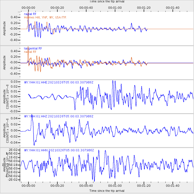
Signal To Noise
| Channel | StoN | STA | LTA |
| WY:YHH:01:HHZ:20210326T05:00:03.307986Z | 9.451966 | 2.7279993E-8 | 2.8861713E-9 |
| WY:YHH:01:HHN:20210326T05:00:03.307986Z | 1.6420366 | 4.8274957E-9 | 2.9399443E-9 |
| WY:YHH:01:HHE:20210326T05:00:03.307986Z | 3.3945646 | 8.855167E-9 | 2.6086313E-9 |
| Arrivals |
| Ps | |
| PpPs | |
| PsPs/PpSs | |


