You are here: Home > Network List > GE - GEOFON Stations List
> Station VSU GEOFON Station Vasula, Estonia > Earthquake Result Viewer
VSU GEOFON Station Vasula, Estonia - Earthquake Result Viewer
| Earthquake location: |
Kuril Islands |
| Earthquake latitude/longitude: |
47.2/151.3 |
| Earthquake time(UTC): |
2004/07/08 (190) 10:30:49 GMT |
| Earthquake Depth: |
128 km |
| Earthquake Magnitude: |
5.9 MB, 6.4 MW, 6.3 MW |
| Earthquake Catalog/Contributor: |
WHDF/NEIC |
|
| Network: |
GE GEOFON |
| Station: |
VSU GEOFON Station Vasula, Estonia |
| Lat/Lon: |
58.46 N/26.73 E |
| Elevation: |
63 m |
|
| Distance: |
65.2 deg |
| Az: |
331.533 deg |
| Baz: |
38.199 deg |
| Ray Param: |
0.05804597 |
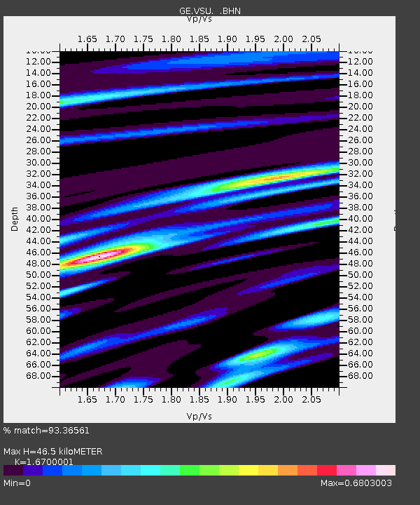
| Estimated Moho Depth: |
46.5 km |
| Estimated Crust Vp/Vs: |
1.67 |
| Assumed Crust Vp: |
6.552 km/s |
| Estimated Crust Vs: |
3.924 km/s |
| Estimated Crust Poisson's Ratio: |
0.22 |
|
| Radial Match: |
93.36561 % |
| Radial Bump: |
342 |
| Transverse Match: |
74.62242 % |
| Transverse Bump: |
400 |
| SOD ConfigId: |
2459 |
| Insert Time: |
2010-03-09 06:53:31.208 +0000 |
| GWidth: |
2.5 |
| Max Bumps: |
400 |
| Tol: |
0.001 |
|

Signal To Noise
| Channel | StoN | STA | LTA |
| GE:VSU: :BHN:20040708T10:40:46.193997Z | 13.398009 | 1.0061086E-6 | 7.509389E-8 |
| GE:VSU: :BHE:20040708T10:40:46.193997Z | 6.590365 | 5.292088E-7 | 8.030038E-8 |
| GE:VSU: :BHZ:20040708T10:40:46.193997Z | 39.643112 | 2.2375687E-6 | 5.644281E-8 |
| Arrivals |
| Ps | 5.0 SECOND |
| PpPs | 18 SECOND |
| PsPs/PpSs | 23 SECOND |


