You are here: Home > Network List > AK - Alaska Regional Network Stations List
> Station K20K Telida, AK, USA > Earthquake Result Viewer
K20K Telida, AK, USA - Earthquake Result Viewer
| Earthquake location: |
Northeast Of Taiwan |
| Earthquake latitude/longitude: |
26.1/125.1 |
| Earthquake time(UTC): |
2021/03/26 (085) 22:02:15 GMT |
| Earthquake Depth: |
147 km |
| Earthquake Magnitude: |
5.9 mww |
| Earthquake Catalog/Contributor: |
NEIC PDE/us |
|
| Network: |
AK Alaska Regional Network |
| Station: |
K20K Telida, AK, USA |
| Lat/Lon: |
63.36 N/154.07 W |
| Elevation: |
548 m |
|
| Distance: |
62.9 deg |
| Az: |
29.997 deg |
| Baz: |
274.501 deg |
| Ray Param: |
0.059494462 |
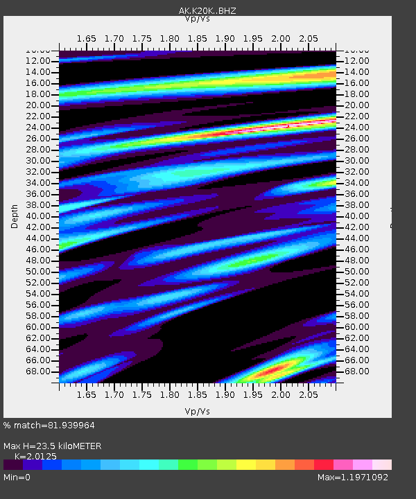
| Estimated Moho Depth: |
23.5 km |
| Estimated Crust Vp/Vs: |
2.01 |
| Assumed Crust Vp: |
6.438 km/s |
| Estimated Crust Vs: |
3.199 km/s |
| Estimated Crust Poisson's Ratio: |
0.34 |
|
| Radial Match: |
81.939964 % |
| Radial Bump: |
400 |
| Transverse Match: |
83.57034 % |
| Transverse Bump: |
356 |
| SOD ConfigId: |
24334971 |
| Insert Time: |
2021-04-09 22:05:13.582 +0000 |
| GWidth: |
2.5 |
| Max Bumps: |
400 |
| Tol: |
0.001 |
|

Signal To Noise
| Channel | StoN | STA | LTA |
| AK:K20K: :BHZ:20210326T22:11:55.439983Z | 2.3988917 | 9.563032E-7 | 3.9864375E-7 |
| AK:K20K: :BHN:20210326T22:11:55.439983Z | 1.6116501 | 5.7277435E-7 | 3.553962E-7 |
| AK:K20K: :BHE:20210326T22:11:55.439983Z | 2.5861778 | 3.869659E-7 | 1.496285E-7 |
| Arrivals |
| Ps | 3.8 SECOND |
| PpPs | 11 SECOND |
| PsPs/PpSs | 14 SECOND |


