You are here: Home > Network List > CI - Caltech Regional Seismic Network Stations List
> Station MPM Manuel Prospect Mine, California, USA > Earthquake Result Viewer
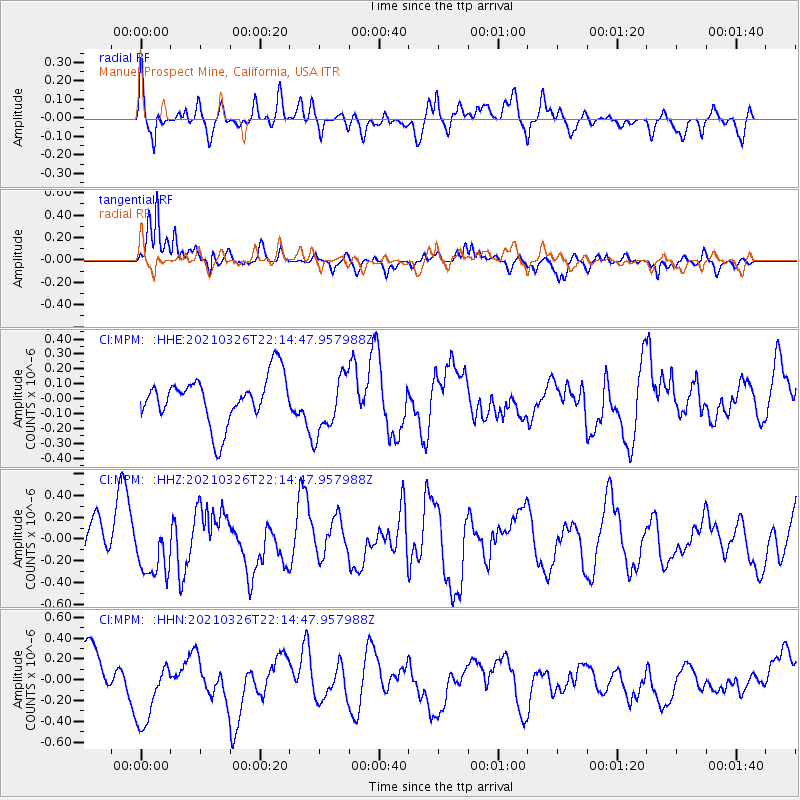
MPM Manuel Prospect Mine, California, USA - Earthquake Result Viewer
*The percent match for this event was below the threshold and hence no stack was calculated.
| Earthquake location: |
Northeast Of Taiwan |
| Earthquake latitude/longitude: |
26.1/125.1 |
| Earthquake time(UTC): |
2021/03/26 (085) 22:02:15 GMT |
| Earthquake Depth: |
147 km |
| Earthquake Magnitude: |
5.9 mww |
| Earthquake Catalog/Contributor: |
NEIC PDE/us |
|
| Network: |
CI Caltech Regional Seismic Network |
| Station: |
MPM Manuel Prospect Mine, California, USA |
| Lat/Lon: |
36.06 N/117.49 W |
| Elevation: |
185 m |
|
| Distance: |
94.5 deg |
| Az: |
46.173 deg |
| Baz: |
306.832 deg |
| Ray Param: |
$rayparam |
*The percent match for this event was below the threshold and hence was not used in the summary stack. |
|
| Radial Match: |
52.030323 % |
| Radial Bump: |
400 |
| Transverse Match: |
85.13843 % |
| Transverse Bump: |
400 |
| SOD ConfigId: |
24334971 |
| Insert Time: |
2021-04-09 22:11:11.215 +0000 |
| GWidth: |
2.5 |
| Max Bumps: |
400 |
| Tol: |
0.001 |
|
Signal To Noise
| Channel | StoN | STA | LTA |
| CI:MPM: :HHZ:20210326T22:14:47.957988Z | 1.0652168 | 2.4266618E-7 | 2.2780921E-7 |
| CI:MPM: :HHN:20210326T22:14:47.957988Z | 1.6336651 | 3.329124E-7 | 2.0378252E-7 |
| CI:MPM: :HHE:20210326T22:14:47.957988Z | 1.2505898 | 1.9717845E-7 | 1.5766835E-7 |
| Arrivals |
| Ps | |
| PpPs | |
| PsPs/PpSs | |


