You are here: Home > Network List > TA - USArray Transportable Network (new EarthScope stations) Stations List
> Station I28M Miner Creek, YT, CAN > Earthquake Result Viewer
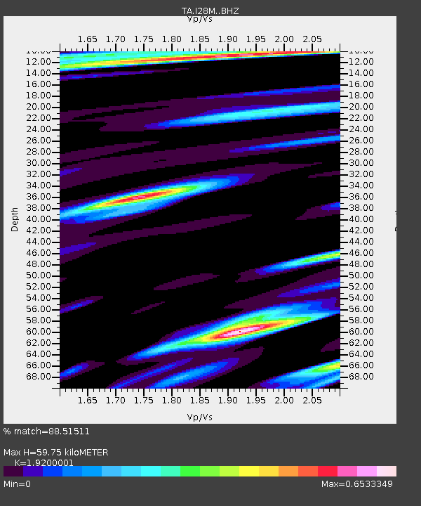
I28M Miner Creek, YT, CAN - Earthquake Result Viewer
| Earthquake location: |
Northeast Of Taiwan |
| Earthquake latitude/longitude: |
26.1/125.1 |
| Earthquake time(UTC): |
2021/03/26 (085) 22:02:15 GMT |
| Earthquake Depth: |
147 km |
| Earthquake Magnitude: |
5.9 mww |
| Earthquake Catalog/Contributor: |
NEIC PDE/us |
|
| Network: |
TA USArray Transportable Network (new EarthScope stations) |
| Station: |
I28M Miner Creek, YT, CAN |
| Lat/Lon: |
65.45 N/139.94 W |
| Elevation: |
1188 m |
|
| Distance: |
68.6 deg |
| Az: |
26.561 deg |
| Baz: |
285.833 deg |
| Ray Param: |
0.05581613 |
| Estimated Moho Depth: |
59.75 km |
| Estimated Crust Vp/Vs: |
1.92 |
| Assumed Crust Vp: |
6.566 km/s |
| Estimated Crust Vs: |
3.42 km/s |
| Estimated Crust Poisson's Ratio: |
0.31 |
|
| Radial Match: |
88.51511 % |
| Radial Bump: |
400 |
| Transverse Match: |
91.4407 % |
| Transverse Bump: |
350 |
| SOD ConfigId: |
24334971 |
| Insert Time: |
2021-04-09 22:18:49.249 +0000 |
| GWidth: |
2.5 |
| Max Bumps: |
400 |
| Tol: |
0.001 |
|

Signal To Noise
| Channel | StoN | STA | LTA |
| TA:I28M: :BHZ:20210326T22:12:31.62498Z | 2.9243872 | 1.2598783E-6 | 4.308179E-7 |
| TA:I28M: :BHN:20210326T22:12:31.62498Z | 1.2732708 | 3.3727565E-7 | 2.6488917E-7 |
| TA:I28M: :BHE:20210326T22:12:31.62498Z | 2.1120489 | 4.969204E-7 | 2.3527882E-7 |
| Arrivals |
| Ps | 8.7 SECOND |
| PpPs | 26 SECOND |
| PsPs/PpSs | 34 SECOND |


