You are here: Home > Network List > IW - Intermountain West Stations List
> Station MOOW Moose Ponds, Wyoming, USA > Earthquake Result Viewer
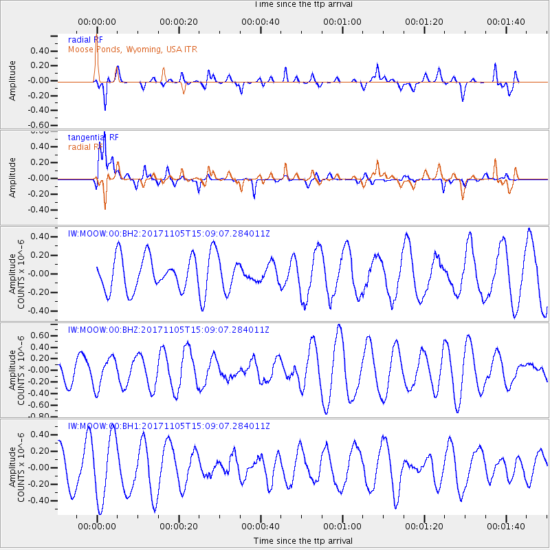
MOOW Moose Ponds, Wyoming, USA - Earthquake Result Viewer
*The percent match for this event was below the threshold and hence no stack was calculated.
| Earthquake location: |
Windward Islands |
| Earthquake latitude/longitude: |
11.7/-61.2 |
| Earthquake time(UTC): |
2017/11/05 (309) 15:00:24 GMT |
| Earthquake Depth: |
47 km |
| Earthquake Magnitude: |
5.5 Mww |
| Earthquake Catalog/Contributor: |
NEIC PDE/us |
|
| Network: |
IW Intermountain West |
| Station: |
MOOW Moose Ponds, Wyoming, USA |
| Lat/Lon: |
43.75 N/110.74 W |
| Elevation: |
2128 m |
|
| Distance: |
53.2 deg |
| Az: |
316.463 deg |
| Baz: |
111.394 deg |
| Ray Param: |
$rayparam |
*The percent match for this event was below the threshold and hence was not used in the summary stack. |
|
| Radial Match: |
68.078514 % |
| Radial Bump: |
400 |
| Transverse Match: |
53.93317 % |
| Transverse Bump: |
335 |
| SOD ConfigId: |
2429771 |
| Insert Time: |
2017-11-19 15:02:07.281 +0000 |
| GWidth: |
2.5 |
| Max Bumps: |
400 |
| Tol: |
0.001 |
|
Signal To Noise
| Channel | StoN | STA | LTA |
| IW:MOOW:00:BHZ:20171105T15:09:07.284011Z | 1.311427 | 2.608737E-7 | 1.9892353E-7 |
| IW:MOOW:00:BH1:20171105T15:09:07.284011Z | 1.8310819 | 3.9596654E-7 | 2.1624732E-7 |
| IW:MOOW:00:BH2:20171105T15:09:07.284011Z | 1.002448 | 1.7277875E-7 | 1.7235682E-7 |
| Arrivals |
| Ps | |
| PpPs | |
| PsPs/PpSs | |


