You are here: Home > Network List > US - United States National Seismic Network Stations List
> Station EGMT Eagleton, Montana, USA > Earthquake Result Viewer
EGMT Eagleton, Montana, USA - Earthquake Result Viewer
*The percent match for this event was below the threshold and hence no stack was calculated.
| Earthquake location: |
Northeast Of Taiwan |
| Earthquake latitude/longitude: |
26.1/125.1 |
| Earthquake time(UTC): |
2021/03/26 (085) 22:02:15 GMT |
| Earthquake Depth: |
147 km |
| Earthquake Magnitude: |
5.9 mww |
| Earthquake Catalog/Contributor: |
NEIC PDE/us |
|
| Network: |
US United States National Seismic Network |
| Station: |
EGMT Eagleton, Montana, USA |
| Lat/Lon: |
48.02 N/109.75 W |
| Elevation: |
1055 m |
|
| Distance: |
91.3 deg |
| Az: |
33.293 deg |
| Baz: |
312.685 deg |
| Ray Param: |
$rayparam |
*The percent match for this event was below the threshold and hence was not used in the summary stack. |
|
| Radial Match: |
57.28062 % |
| Radial Bump: |
400 |
| Transverse Match: |
79.36665 % |
| Transverse Bump: |
400 |
| SOD ConfigId: |
24334971 |
| Insert Time: |
2021-04-09 22:20:00.854 +0000 |
| GWidth: |
2.5 |
| Max Bumps: |
400 |
| Tol: |
0.001 |
|
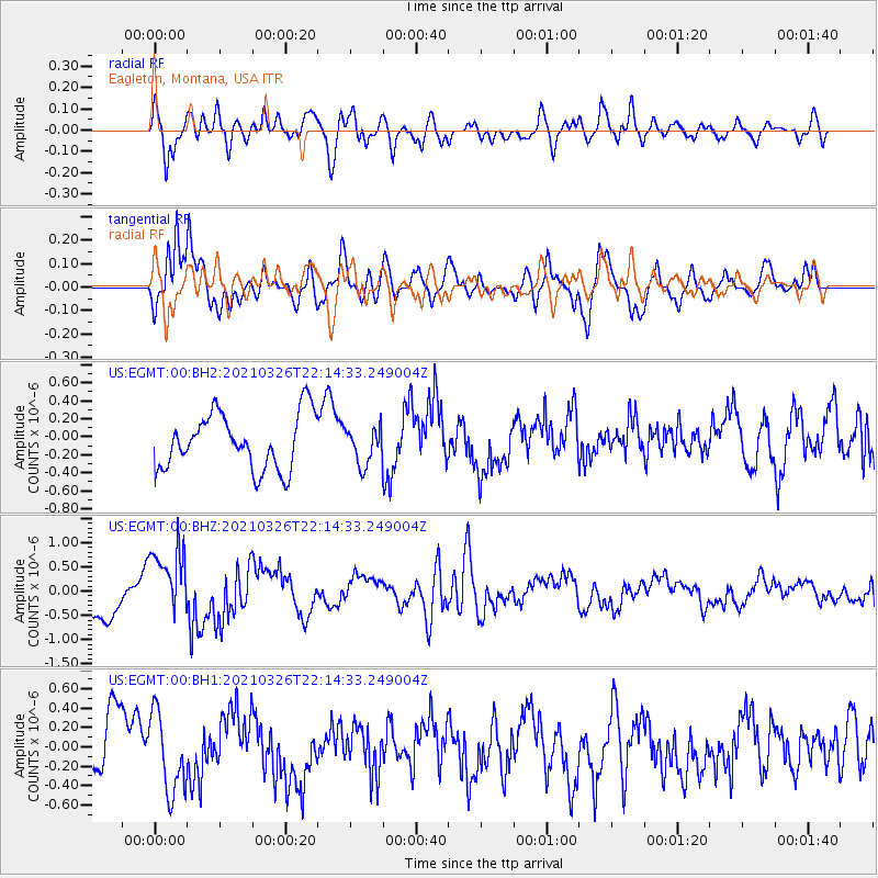
Signal To Noise
| Channel | StoN | STA | LTA |
| US:EGMT:00:BHZ:20210326T22:14:33.249004Z | 2.0318296 | 7.481947E-7 | 3.682369E-7 |
| US:EGMT:00:BH1:20210326T22:14:33.249004Z | 1.564507 | 4.096823E-7 | 2.618603E-7 |
| US:EGMT:00:BH2:20210326T22:14:33.249004Z | 0.6689021 | 2.0365775E-7 | 3.044657E-7 |
| Arrivals |
| Ps | |
| PpPs | |
| PsPs/PpSs | |


