You are here: Home > Network List > AV - Alaska Volcano Observatory Stations List
> Station MAPS Pakushin Southeast, Makushin Volcano, Alaska > Earthquake Result Viewer
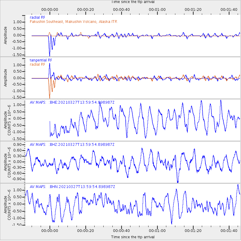
MAPS Pakushin Southeast, Makushin Volcano, Alaska - Earthquake Result Viewer
*The percent match for this event was below the threshold and hence no stack was calculated.
| Earthquake location: |
Adriatic Sea |
| Earthquake latitude/longitude: |
42.4/16.0 |
| Earthquake time(UTC): |
2021/03/27 (086) 13:47:55 GMT |
| Earthquake Depth: |
10 km |
| Earthquake Magnitude: |
5.5 mww |
| Earthquake Catalog/Contributor: |
NEIC PDE/us |
|
| Network: |
AV Alaska Volcano Observatory |
| Station: |
MAPS Pakushin Southeast, Makushin Volcano, Alaska |
| Lat/Lon: |
53.81 N/166.94 W |
| Elevation: |
333 m |
|
| Distance: |
84.1 deg |
| Az: |
1.781 deg |
| Baz: |
357.777 deg |
| Ray Param: |
$rayparam |
*The percent match for this event was below the threshold and hence was not used in the summary stack. |
|
| Radial Match: |
78.36224 % |
| Radial Bump: |
400 |
| Transverse Match: |
63.54063 % |
| Transverse Bump: |
400 |
| SOD ConfigId: |
24334971 |
| Insert Time: |
2021-04-10 13:54:33.172 +0000 |
| GWidth: |
2.5 |
| Max Bumps: |
400 |
| Tol: |
0.001 |
|
Signal To Noise
| Channel | StoN | STA | LTA |
| AV:MAPS: :BHZ:20210327T13:59:54.898987Z | 1.3788731 | 5.615855E-7 | 4.072786E-7 |
| AV:MAPS: :BHN:20210327T13:59:54.898987Z | 1.8806171 | 1.3484365E-6 | 7.1701805E-7 |
| AV:MAPS: :BHE:20210327T13:59:54.898987Z | 1.5470186 | 8.231084E-7 | 5.3206105E-7 |
| Arrivals |
| Ps | |
| PpPs | |
| PsPs/PpSs | |


