You are here: Home > Network List > AV - Alaska Volcano Observatory Stations List
> Station SPCR Ckakachatna River, Mount Spurr, Alaska > Earthquake Result Viewer
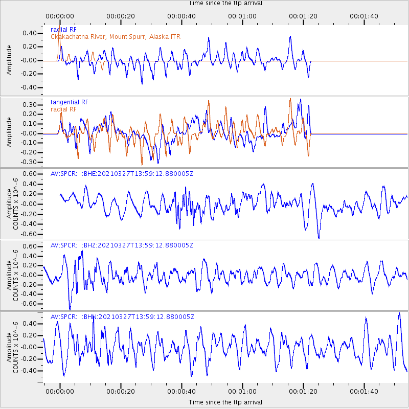
SPCR Ckakachatna River, Mount Spurr, Alaska - Earthquake Result Viewer
*The percent match for this event was below the threshold and hence no stack was calculated.
| Earthquake location: |
Adriatic Sea |
| Earthquake latitude/longitude: |
42.4/16.0 |
| Earthquake time(UTC): |
2021/03/27 (086) 13:47:55 GMT |
| Earthquake Depth: |
10 km |
| Earthquake Magnitude: |
5.5 mww |
| Earthquake Catalog/Contributor: |
NEIC PDE/us |
|
| Network: |
AV Alaska Volcano Observatory |
| Station: |
SPCR Ckakachatna River, Mount Spurr, Alaska |
| Lat/Lon: |
61.20 N/152.21 W |
| Elevation: |
984 m |
|
| Distance: |
76.3 deg |
| Az: |
354.177 deg |
| Baz: |
8.922 deg |
| Ray Param: |
$rayparam |
*The percent match for this event was below the threshold and hence was not used in the summary stack. |
|
| Radial Match: |
53.43476 % |
| Radial Bump: |
360 |
| Transverse Match: |
53.423103 % |
| Transverse Bump: |
400 |
| SOD ConfigId: |
24334971 |
| Insert Time: |
2021-04-10 13:54:49.007 +0000 |
| GWidth: |
2.5 |
| Max Bumps: |
400 |
| Tol: |
0.001 |
|
Signal To Noise
| Channel | StoN | STA | LTA |
| AV:SPCR: :BHZ:20210327T13:59:12.880005Z | 1.7806437 | 3.1722647E-7 | 1.7815269E-7 |
| AV:SPCR: :BHN:20210327T13:59:12.880005Z | 1.4209951 | 3.0347303E-7 | 2.1356375E-7 |
| AV:SPCR: :BHE:20210327T13:59:12.880005Z | 0.90629524 | 1.358188E-7 | 1.4986153E-7 |
| Arrivals |
| Ps | |
| PpPs | |
| PsPs/PpSs | |


