You are here: Home > Network List > WY - Yellowstone Wyoming Seismic Network Stations List
> Station YNR Norris Junction, YNP, WY, USA > Earthquake Result Viewer
YNR Norris Junction, YNP, WY, USA - Earthquake Result Viewer
*The percent match for this event was below the threshold and hence no stack was calculated.
| Earthquake location: |
Adriatic Sea |
| Earthquake latitude/longitude: |
42.4/16.0 |
| Earthquake time(UTC): |
2021/03/27 (086) 13:47:55 GMT |
| Earthquake Depth: |
10 km |
| Earthquake Magnitude: |
5.5 mww |
| Earthquake Catalog/Contributor: |
NEIC PDE/us |
|
| Network: |
WY Yellowstone Wyoming Seismic Network |
| Station: |
YNR Norris Junction, YNP, WY, USA |
| Lat/Lon: |
44.72 N/110.68 W |
| Elevation: |
2336 m |
|
| Distance: |
81.0 deg |
| Az: |
324.653 deg |
| Baz: |
36.914 deg |
| Ray Param: |
$rayparam |
*The percent match for this event was below the threshold and hence was not used in the summary stack. |
|
| Radial Match: |
65.78901 % |
| Radial Bump: |
400 |
| Transverse Match: |
65.28115 % |
| Transverse Bump: |
400 |
| SOD ConfigId: |
24334971 |
| Insert Time: |
2021-04-10 14:15:49.728 +0000 |
| GWidth: |
2.5 |
| Max Bumps: |
400 |
| Tol: |
0.001 |
|
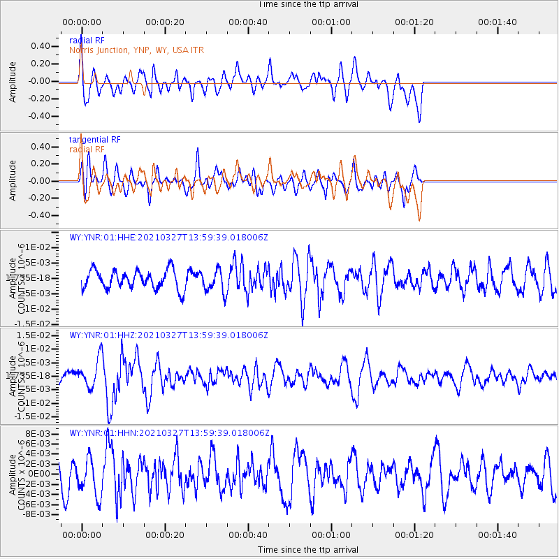
Signal To Noise
| Channel | StoN | STA | LTA |
| WY:YNR:01:HHZ:20210327T13:59:39.018006Z | 2.6852918 | 5.3399556E-9 | 1.9885942E-9 |
| WY:YNR:01:HHN:20210327T13:59:39.018006Z | 1.2736474 | 3.7280476E-9 | 2.9270641E-9 |
| WY:YNR:01:HHE:20210327T13:59:39.018006Z | 1.2213469 | 3.7084202E-9 | 3.0363365E-9 |
| Arrivals |
| Ps | |
| PpPs | |
| PsPs/PpSs | |


