You are here: Home > Network List > II - Global Seismograph Network (GSN - IRIS/IDA) Stations List
> Station WRAB Tennant Creek, NT, Australia > Earthquake Result Viewer
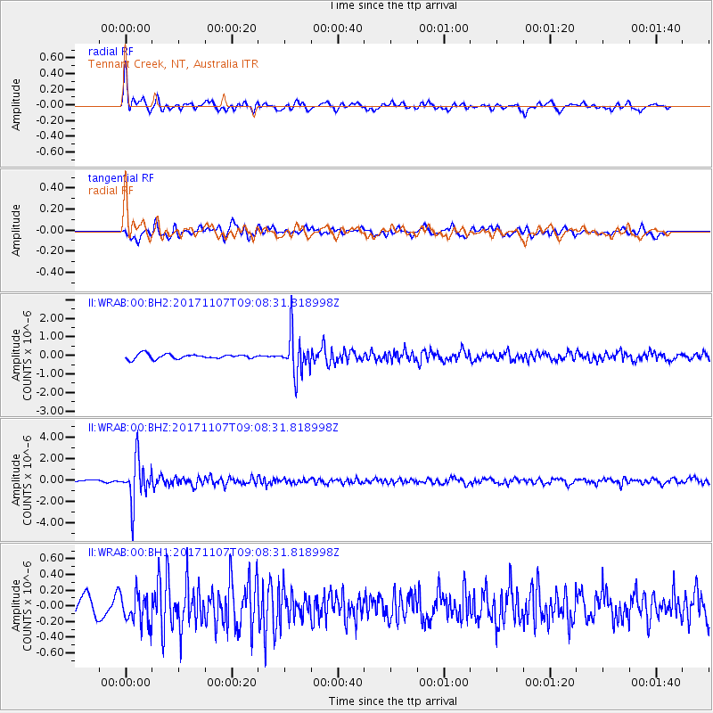
WRAB Tennant Creek, NT, Australia - Earthquake Result Viewer
*The percent match for this event was below the threshold and hence no stack was calculated.
| Earthquake location: |
Fiji Islands Region |
| Earthquake latitude/longitude: |
-17.7/-178.5 |
| Earthquake time(UTC): |
2017/11/07 (311) 09:01:39 GMT |
| Earthquake Depth: |
555 km |
| Earthquake Magnitude: |
5.7 Mww |
| Earthquake Catalog/Contributor: |
NEIC PDE/us |
|
| Network: |
II Global Seismograph Network (GSN - IRIS/IDA) |
| Station: |
WRAB Tennant Creek, NT, Australia |
| Lat/Lon: |
19.93 S/134.36 E |
| Elevation: |
366 m |
|
| Distance: |
44.5 deg |
| Az: |
259.334 deg |
| Baz: |
95.24 deg |
| Ray Param: |
$rayparam |
*The percent match for this event was below the threshold and hence was not used in the summary stack. |
|
| Radial Match: |
70.84859 % |
| Radial Bump: |
365 |
| Transverse Match: |
70.75615 % |
| Transverse Bump: |
400 |
| SOD ConfigId: |
2429771 |
| Insert Time: |
2017-11-21 09:03:19.064 +0000 |
| GWidth: |
2.5 |
| Max Bumps: |
400 |
| Tol: |
0.001 |
|
Signal To Noise
| Channel | StoN | STA | LTA |
| II:WRAB:00:BHZ:20171107T09:08:31.818998Z | 11.346878 | 1.9716774E-6 | 1.7376387E-7 |
| II:WRAB:00:BH1:20171107T09:08:31.818998Z | 1.7902784 | 1.9491277E-7 | 1.0887289E-7 |
| II:WRAB:00:BH2:20171107T09:08:31.818998Z | 8.435692 | 1.0582909E-6 | 1.2545395E-7 |
| Arrivals |
| Ps | |
| PpPs | |
| PsPs/PpSs | |


