You are here: Home > Network List > GE - GEOFON Stations List
> Station SUMG GEOFON Station Summit Camp, Greenland > Earthquake Result Viewer
SUMG GEOFON Station Summit Camp, Greenland - Earthquake Result Viewer
| Earthquake location: |
Near Coast Of Peru |
| Earthquake latitude/longitude: |
-13.6/-76.6 |
| Earthquake time(UTC): |
2007/08/19 (231) 01:22:40 GMT |
| Earthquake Depth: |
26 km |
| Earthquake Magnitude: |
5.9 MB, 5.4 MS, 5.8 MW, 5.5 ML |
| Earthquake Catalog/Contributor: |
WHDF/NEIC |
|
| Network: |
GE GEOFON |
| Station: |
SUMG GEOFON Station Summit Camp, Greenland |
| Lat/Lon: |
72.58 N/38.45 W |
| Elevation: |
3260 m |
|
| Distance: |
89.6 deg |
| Az: |
10.729 deg |
| Baz: |
216.922 deg |
| Ray Param: |
0.041730724 |
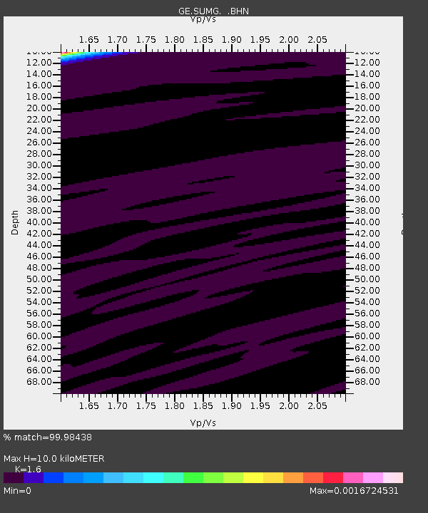
| Estimated Moho Depth: |
10.0 km |
| Estimated Crust Vp/Vs: |
1.60 |
| Assumed Crust Vp: |
6.261 km/s |
| Estimated Crust Vs: |
3.913 km/s |
| Estimated Crust Poisson's Ratio: |
0.18 |
|
| Radial Match: |
99.98438 % |
| Radial Bump: |
9 |
| Transverse Match: |
99.76239 % |
| Transverse Bump: |
20 |
| SOD ConfigId: |
2564 |
| Insert Time: |
2010-03-09 06:57:05.712 +0000 |
| GWidth: |
2.5 |
| Max Bumps: |
400 |
| Tol: |
0.001 |
|

Signal To Noise
| Channel | StoN | STA | LTA |
| GE:SUMG: :BHN:20070819T01:35:04.44302Z | 0.9550112 | 5.456968E-7 | 5.7140363E-7 |
| GE:SUMG: :BHE:20070819T01:35:04.44302Z | 0.75725424 | 2.6770454E-7 | 3.5352002E-7 |
| GE:SUMG: :BHZ:20070819T01:35:04.44302Z | 1.0716382 | 5.152043E-7 | 4.807633E-7 |
| Arrivals |
| Ps | 1.0 SECOND |
| PpPs | 4.1 SECOND |
| PsPs/PpSs | 5.0 SECOND |


