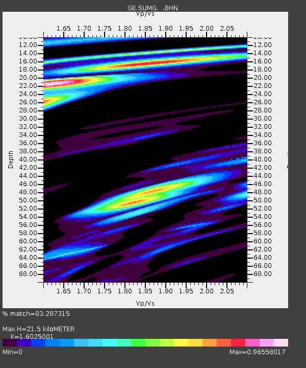
SUMG GEOFON Station Summit Camp, Greenland - Earthquake Result Viewer

Earthquake location: Near East Coast Of Honshu, Japan
Earthquake latitude/longitude: 35.5/140.9
Earthquake time(UTC): 2009/06/06 (157) 05:52:43 GMT
Earthquake Depth: 34 km
Earthquake Magnitude: 5.8 MB, 5.4 MS, 5.8 MW, 5.7 MW
Earthquake Catalog/Contributor: WHDF/NEIC
Network: GE GEOFON
Station: SUMG GEOFON Station Summit Camp, Greenland
Lat/Lon: 72.58 N/38.45 W
Elevation: 3260 m
Distance: 72.2 deg
Az: 359.8 deg
Baz: 0.542 deg
Ray Param: 0.05374624
Estimated Moho Depth: 21.5 km
Estimated Crust Vp/Vs: 1.60
Assumed Crust Vp: 6.261 km/s
Estimated Crust Vs: 3.907 km/s
Estimated Crust Poisson's Ratio: 0.18
Radial Match: 83.287315 %
Radial Bump: 400
Transverse Match: 73.47572 %
Transverse Bump: 400
SOD ConfigId: 2648
Insert Time: 2010-03-09 06:57:23.241 +0000
GWidth: 2.5
Max Bumps: 400
Tol: 0.001

Signal To Noise

ChannelStoNSTALTA
GE:SUMG: :BHN:20090606T06:03:34.094006Z7.95555351.326517E-61.66741E-7
GE:SUMG: :BHE:20090606T06:03:34.094006Z1.98437083.2858318E-71.6558558E-7
GE:SUMG: :BHZ:20090606T06:03:34.094006Z2.10851432.477093E-71.1748048E-7
Arrivals
Ps2.1 SECOND
PpPs8.6 SECOND
PsPs/PpSs11 SECOND