You are here: Home > Network List > GE - GEOFON Stations List
> Station SUMG GEOFON Station Summit Camp, Greenland > Earthquake Result Viewer
SUMG GEOFON Station Summit Camp, Greenland - Earthquake Result Viewer
| Earthquake location: |
Tajikistan |
| Earthquake latitude/longitude: |
38.1/72.7 |
| Earthquake time(UTC): |
2005/02/25 (056) 23:04:04 GMT |
| Earthquake Depth: |
115 km |
| Earthquake Magnitude: |
6.1 MB, 5.7 MW, 5.7 MW |
| Earthquake Catalog/Contributor: |
WHDF/NEIC |
|
| Network: |
GE GEOFON |
| Station: |
SUMG GEOFON Station Summit Camp, Greenland |
| Lat/Lon: |
72.58 N/38.45 W |
| Elevation: |
3260 m |
|
| Distance: |
60.0 deg |
| Az: |
341.067 deg |
| Baz: |
58.169 deg |
| Ray Param: |
0.061491467 |
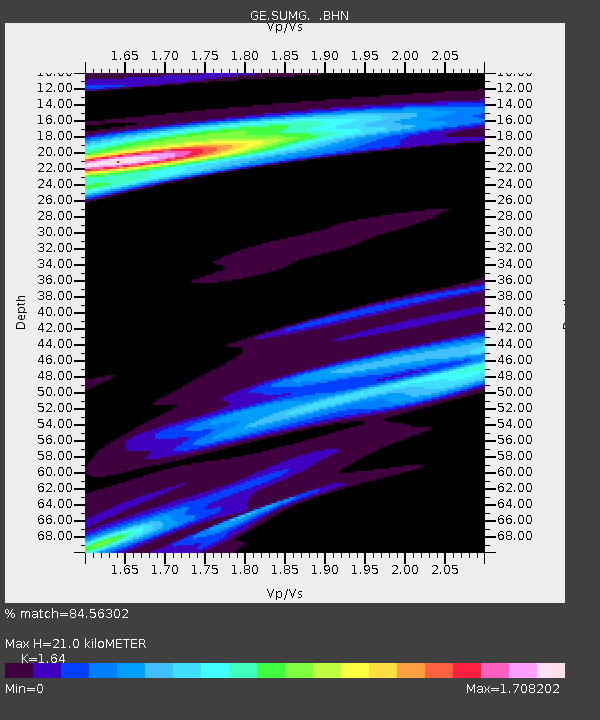
| Estimated Moho Depth: |
21.0 km |
| Estimated Crust Vp/Vs: |
1.64 |
| Assumed Crust Vp: |
6.261 km/s |
| Estimated Crust Vs: |
3.818 km/s |
| Estimated Crust Poisson's Ratio: |
0.20 |
|
| Radial Match: |
84.56302 % |
| Radial Bump: |
400 |
| Transverse Match: |
71.319565 % |
| Transverse Bump: |
400 |
| SOD ConfigId: |
2455 |
| Insert Time: |
2010-03-09 06:57:44.276 +0000 |
| GWidth: |
2.5 |
| Max Bumps: |
400 |
| Tol: |
0.001 |
|

Signal To Noise
| Channel | StoN | STA | LTA |
| GE:SUMG: :BHN:20050225T23:13:27.743999Z | 2.6248004 | 3.315555E-7 | 1.2631645E-7 |
| GE:SUMG: :BHE:20050225T23:13:27.743999Z | 4.4290147 | 5.7180955E-7 | 1.2910537E-7 |
| GE:SUMG: :BHZ:20050225T23:13:27.743999Z | 14.973023 | 2.335377E-6 | 1.5597232E-7 |
| Arrivals |
| Ps | 2.3 SECOND |
| PpPs | 8.4 SECOND |
| PsPs/PpSs | 11 SECOND |


