You are here: Home > Network List > CI - Caltech Regional Seismic Network Stations List
> Station MPM Manuel Prospect Mine, California, USA > Earthquake Result Viewer
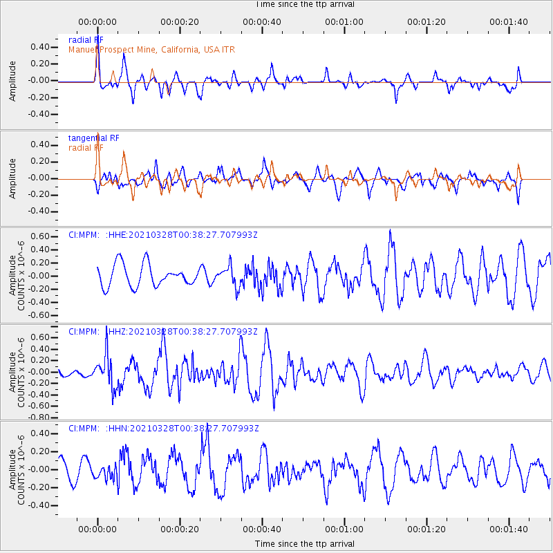
MPM Manuel Prospect Mine, California, USA - Earthquake Result Viewer
*The percent match for this event was below the threshold and hence no stack was calculated.
| Earthquake location: |
Southeast Of Honshu, Japan |
| Earthquake latitude/longitude: |
33.6/140.3 |
| Earthquake time(UTC): |
2021/03/28 (087) 00:26:56 GMT |
| Earthquake Depth: |
48 km |
| Earthquake Magnitude: |
5.7 mww |
| Earthquake Catalog/Contributor: |
NEIC PDE/us |
|
| Network: |
CI Caltech Regional Seismic Network |
| Station: |
MPM Manuel Prospect Mine, California, USA |
| Lat/Lon: |
36.06 N/117.49 W |
| Elevation: |
185 m |
|
| Distance: |
79.6 deg |
| Az: |
53.638 deg |
| Baz: |
303.997 deg |
| Ray Param: |
$rayparam |
*The percent match for this event was below the threshold and hence was not used in the summary stack. |
|
| Radial Match: |
68.32167 % |
| Radial Bump: |
400 |
| Transverse Match: |
67.68566 % |
| Transverse Bump: |
400 |
| SOD ConfigId: |
24334971 |
| Insert Time: |
2021-04-11 00:35:55.233 +0000 |
| GWidth: |
2.5 |
| Max Bumps: |
400 |
| Tol: |
0.001 |
|
Signal To Noise
| Channel | StoN | STA | LTA |
| CI:MPM: :HHZ:20210328T00:38:27.707993Z | 1.5147759 | 2.987919E-7 | 1.9725155E-7 |
| CI:MPM: :HHN:20210328T00:38:27.707993Z | 0.7273813 | 7.646065E-8 | 1.0511771E-7 |
| CI:MPM: :HHE:20210328T00:38:27.707993Z | 0.96647525 | 1.5937285E-7 | 1.6490111E-7 |
| Arrivals |
| Ps | |
| PpPs | |
| PsPs/PpSs | |


