You are here: Home > Network List > GE - GEOFON Stations List
> Station SUMG GEOFON Station Summit Camp, Greenland > Earthquake Result Viewer
SUMG GEOFON Station Summit Camp, Greenland - Earthquake Result Viewer
| Earthquake location: |
Kyushu, Japan |
| Earthquake latitude/longitude: |
31.0/130.0 |
| Earthquake time(UTC): |
2005/11/21 (325) 15:36:30 GMT |
| Earthquake Depth: |
145 km |
| Earthquake Magnitude: |
5.9 MB, 6.2 MW, 6.2 MW |
| Earthquake Catalog/Contributor: |
WHDF/NEIC |
|
| Network: |
GE GEOFON |
| Station: |
SUMG GEOFON Station Summit Camp, Greenland |
| Lat/Lon: |
72.58 N/38.45 W |
| Elevation: |
3260 m |
|
| Distance: |
76.4 deg |
| Az: |
356.442 deg |
| Baz: |
10.187 deg |
| Ray Param: |
0.05067862 |
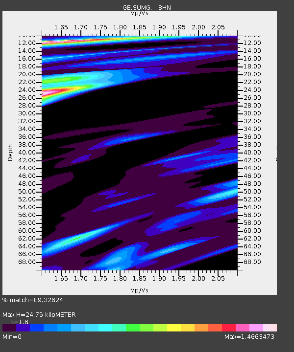
| Estimated Moho Depth: |
24.75 km |
| Estimated Crust Vp/Vs: |
1.60 |
| Assumed Crust Vp: |
6.261 km/s |
| Estimated Crust Vs: |
3.913 km/s |
| Estimated Crust Poisson's Ratio: |
0.18 |
|
| Radial Match: |
89.32624 % |
| Radial Bump: |
400 |
| Transverse Match: |
80.241684 % |
| Transverse Bump: |
400 |
| SOD ConfigId: |
2448 |
| Insert Time: |
2010-03-09 06:57:51.377 +0000 |
| GWidth: |
2.5 |
| Max Bumps: |
400 |
| Tol: |
0.001 |
|

Signal To Noise
| Channel | StoN | STA | LTA |
| GE:SUMG: :BHN:20051121T15:47:33.295002Z | 1.3250995 | 9.4093764E-7 | 7.100883E-7 |
| GE:SUMG: :BHE:20051121T15:47:33.295002Z | 0.6024091 | 3.5150953E-7 | 5.835063E-7 |
| GE:SUMG: :BHZ:20051121T15:47:33.295002Z | 2.6350987 | 2.8282632E-6 | 1.0733044E-6 |
| Arrivals |
| Ps | 2.5 SECOND |
| PpPs | 9.9 SECOND |
| PsPs/PpSs | 12 SECOND |


