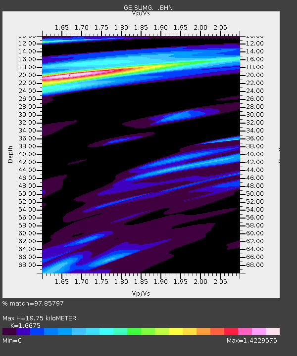
SUMG GEOFON Station Summit Camp, Greenland - Earthquake Result Viewer

Earthquake location: Nicobar Islands, India Region
Earthquake latitude/longitude: 7.9/92.2
Earthquake time(UTC): 2005/07/24 (205) 15:42:06 GMT
Earthquake Depth: 16 km
Earthquake Magnitude: 6.6 MB, 7.5 MS, 7.3 MW, 7.2 MW
Earthquake Catalog/Contributor: WHDF/NEIC
Network: GE GEOFON
Station: SUMG GEOFON Station Summit Camp, Greenland
Lat/Lon: 72.58 N/38.45 W
Elevation: 3260 m
Distance: 93.7 deg
Az: 346.758 deg
Baz: 48.865 deg
Ray Param: 0.041213877
Estimated Moho Depth: 19.75 km
Estimated Crust Vp/Vs: 1.67
Assumed Crust Vp: 6.261 km/s
Estimated Crust Vs: 3.755 km/s
Estimated Crust Poisson's Ratio: 0.22
Radial Match: 97.85797 %
Radial Bump: 400
Transverse Match: 93.70289 %
Transverse Bump: 400
SOD ConfigId: 2475
Insert Time: 2010-03-09 06:57:53.418 +0000
GWidth: 2.5
Max Bumps: 400
Tol: 0.001

Signal To Noise

ChannelStoNSTALTA
GE:SUMG: :BHN:20050724T15:54:50.144021Z1.32087711.15050305E-78.710145E-8
GE:SUMG: :BHE:20050724T15:54:50.144021Z2.03464371.144743E-75.6262575E-8
GE:SUMG: :BHZ:20050724T15:54:50.144021Z9.2307199.567257E-71.0364586E-7
Arrivals
Ps2.1 SECOND
PpPs8.2 SECOND
PsPs/PpSs10 SECOND