You are here: Home > Network List > GE - GEOFON Stations List
> Station SUMG GEOFON Station Summit Camp, Greenland > Earthquake Result Viewer
SUMG GEOFON Station Summit Camp, Greenland - Earthquake Result Viewer
| Earthquake location: |
Sichuan, China |
| Earthquake latitude/longitude: |
32.2/105.0 |
| Earthquake time(UTC): |
2008/05/17 (138) 17:08:25 GMT |
| Earthquake Depth: |
9.0 km |
| Earthquake Magnitude: |
5.8 MB, 5.6 MS, 5.7 MW, 5.7 MW |
| Earthquake Catalog/Contributor: |
WHDF/NEIC |
|
| Network: |
GE GEOFON |
| Station: |
SUMG GEOFON Station Summit Camp, Greenland |
| Lat/Lon: |
72.58 N/38.45 W |
| Elevation: |
3260 m |
|
| Distance: |
72.5 deg |
| Az: |
349.152 deg |
| Baz: |
31.966 deg |
| Ray Param: |
0.05363988 |
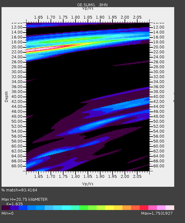
| Estimated Moho Depth: |
20.75 km |
| Estimated Crust Vp/Vs: |
1.63 |
| Assumed Crust Vp: |
6.261 km/s |
| Estimated Crust Vs: |
3.829 km/s |
| Estimated Crust Poisson's Ratio: |
0.20 |
|
| Radial Match: |
93.4164 % |
| Radial Bump: |
395 |
| Transverse Match: |
77.71393 % |
| Transverse Bump: |
400 |
| SOD ConfigId: |
2504 |
| Insert Time: |
2010-03-09 06:58:01.243 +0000 |
| GWidth: |
2.5 |
| Max Bumps: |
400 |
| Tol: |
0.001 |
|

Signal To Noise
| Channel | StoN | STA | LTA |
| GE:SUMG: :BHN:20080517T17:19:20.995015Z | 19.301888 | 1.6069733E-6 | 8.325472E-8 |
| GE:SUMG: :BHE:20080517T17:19:20.995015Z | 2.4214656 | 2.235777E-7 | 9.233156E-8 |
| GE:SUMG: :BHZ:20080517T17:19:20.995015Z | 2.148234 | 1.5495621E-7 | 7.213191E-8 |
| Arrivals |
| Ps | 2.2 SECOND |
| PpPs | 8.4 SECOND |
| PsPs/PpSs | 11 SECOND |


