You are here: Home > Network List > TA - USArray Transportable Network (new EarthScope stations) Stations List
> Station D23K Nanushuk River, AK USA > Earthquake Result Viewer
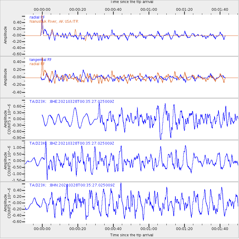
D23K Nanushuk River, AK USA - Earthquake Result Viewer
*The percent match for this event was below the threshold and hence no stack was calculated.
| Earthquake location: |
Southeast Of Honshu, Japan |
| Earthquake latitude/longitude: |
33.6/140.3 |
| Earthquake time(UTC): |
2021/03/28 (087) 00:26:56 GMT |
| Earthquake Depth: |
48 km |
| Earthquake Magnitude: |
5.7 mww |
| Earthquake Catalog/Contributor: |
NEIC PDE/us |
|
| Network: |
TA USArray Transportable Network (new EarthScope stations) |
| Station: |
D23K Nanushuk River, AK USA |
| Lat/Lon: |
68.97 N/150.68 W |
| Elevation: |
406 m |
|
| Distance: |
51.5 deg |
| Az: |
25.5 deg |
| Baz: |
264.145 deg |
| Ray Param: |
$rayparam |
*The percent match for this event was below the threshold and hence was not used in the summary stack. |
|
| Radial Match: |
71.27645 % |
| Radial Bump: |
400 |
| Transverse Match: |
61.813427 % |
| Transverse Bump: |
400 |
| SOD ConfigId: |
24334971 |
| Insert Time: |
2021-04-11 00:46:39.546 +0000 |
| GWidth: |
2.5 |
| Max Bumps: |
400 |
| Tol: |
0.001 |
|
Signal To Noise
| Channel | StoN | STA | LTA |
| TA:D23K: :BHZ:20210328T00:35:27.025009Z | 2.9879234 | 6.0714507E-7 | 2.0319966E-7 |
| TA:D23K: :BHN:20210328T00:35:27.025009Z | 0.39299238 | 1.1921712E-7 | 3.033573E-7 |
| TA:D23K: :BHE:20210328T00:35:27.025009Z | 1.1918298 | 2.7184308E-7 | 2.2808885E-7 |
| Arrivals |
| Ps | |
| PpPs | |
| PsPs/PpSs | |


