You are here: Home > Network List > US - United States National Seismic Network Stations List
> Station AMTX Amarillo, Texas, USA > Earthquake Result Viewer
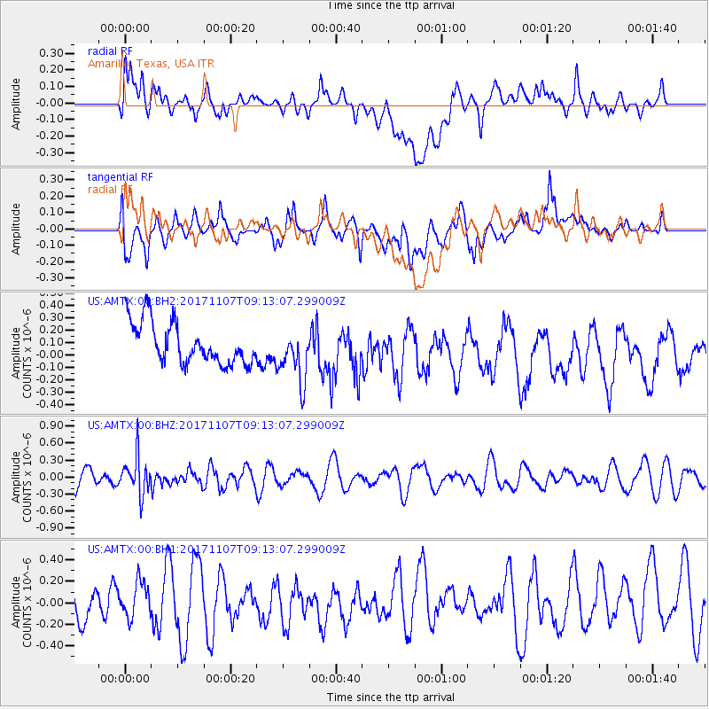
AMTX Amarillo, Texas, USA - Earthquake Result Viewer
*The percent match for this event was below the threshold and hence no stack was calculated.
| Earthquake location: |
Fiji Islands Region |
| Earthquake latitude/longitude: |
-17.7/-178.5 |
| Earthquake time(UTC): |
2017/11/07 (311) 09:01:39 GMT |
| Earthquake Depth: |
555 km |
| Earthquake Magnitude: |
5.7 Mww |
| Earthquake Catalog/Contributor: |
NEIC PDE/us |
|
| Network: |
US United States National Seismic Network |
| Station: |
AMTX Amarillo, Texas, USA |
| Lat/Lon: |
34.53 N/101.41 W |
| Elevation: |
1010 m |
|
| Distance: |
89.7 deg |
| Az: |
53.597 deg |
| Baz: |
248.344 deg |
| Ray Param: |
$rayparam |
*The percent match for this event was below the threshold and hence was not used in the summary stack. |
|
| Radial Match: |
54.407852 % |
| Radial Bump: |
400 |
| Transverse Match: |
49.01649 % |
| Transverse Bump: |
400 |
| SOD ConfigId: |
2429771 |
| Insert Time: |
2017-11-21 09:05:16.517 +0000 |
| GWidth: |
2.5 |
| Max Bumps: |
400 |
| Tol: |
0.001 |
|
Signal To Noise
| Channel | StoN | STA | LTA |
| US:AMTX:00:BHZ:20171107T09:13:07.299009Z | 1.6599046 | 3.4024401E-7 | 2.0497805E-7 |
| US:AMTX:00:BH1:20171107T09:13:07.299009Z | 1.4024982 | 1.7523993E-7 | 1.2494841E-7 |
| US:AMTX:00:BH2:20171107T09:13:07.299009Z | 1.2620318 | 2.0630937E-7 | 1.6347398E-7 |
| Arrivals |
| Ps | |
| PpPs | |
| PsPs/PpSs | |


