You are here: Home > Network List > US - United States National Seismic Network Stations List
> Station HAWA Hanford, Washington, USA > Earthquake Result Viewer
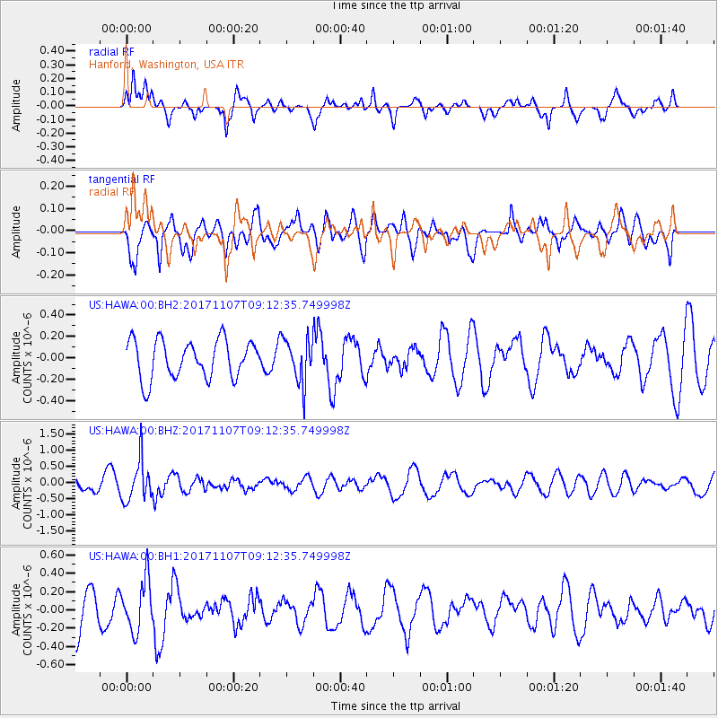
HAWA Hanford, Washington, USA - Earthquake Result Viewer
*The percent match for this event was below the threshold and hence no stack was calculated.
| Earthquake location: |
Fiji Islands Region |
| Earthquake latitude/longitude: |
-17.7/-178.5 |
| Earthquake time(UTC): |
2017/11/07 (311) 09:01:39 GMT |
| Earthquake Depth: |
555 km |
| Earthquake Magnitude: |
5.7 Mww |
| Earthquake Catalog/Contributor: |
NEIC PDE/us |
|
| Network: |
US United States National Seismic Network |
| Station: |
HAWA Hanford, Washington, USA |
| Lat/Lon: |
46.39 N/119.53 W |
| Elevation: |
364 m |
|
| Distance: |
83.0 deg |
| Az: |
36.711 deg |
| Baz: |
235.424 deg |
| Ray Param: |
$rayparam |
*The percent match for this event was below the threshold and hence was not used in the summary stack. |
|
| Radial Match: |
53.50867 % |
| Radial Bump: |
400 |
| Transverse Match: |
51.78736 % |
| Transverse Bump: |
400 |
| SOD ConfigId: |
2429771 |
| Insert Time: |
2017-11-21 09:05:26.549 +0000 |
| GWidth: |
2.5 |
| Max Bumps: |
400 |
| Tol: |
0.001 |
|
Signal To Noise
| Channel | StoN | STA | LTA |
| US:HAWA:00:BHZ:20171107T09:12:35.749998Z | 3.7714622 | 6.293297E-7 | 1.6686623E-7 |
| US:HAWA:00:BH1:20171107T09:12:35.749998Z | 1.1852459 | 2.7778637E-7 | 2.3437023E-7 |
| US:HAWA:00:BH2:20171107T09:12:35.749998Z | 1.1636676 | 2.0696523E-7 | 1.7785598E-7 |
| Arrivals |
| Ps | |
| PpPs | |
| PsPs/PpSs | |


