You are here: Home > Network List > US - United States National Seismic Network Stations List
> Station HLID Hailey, Idaho, USA > Earthquake Result Viewer
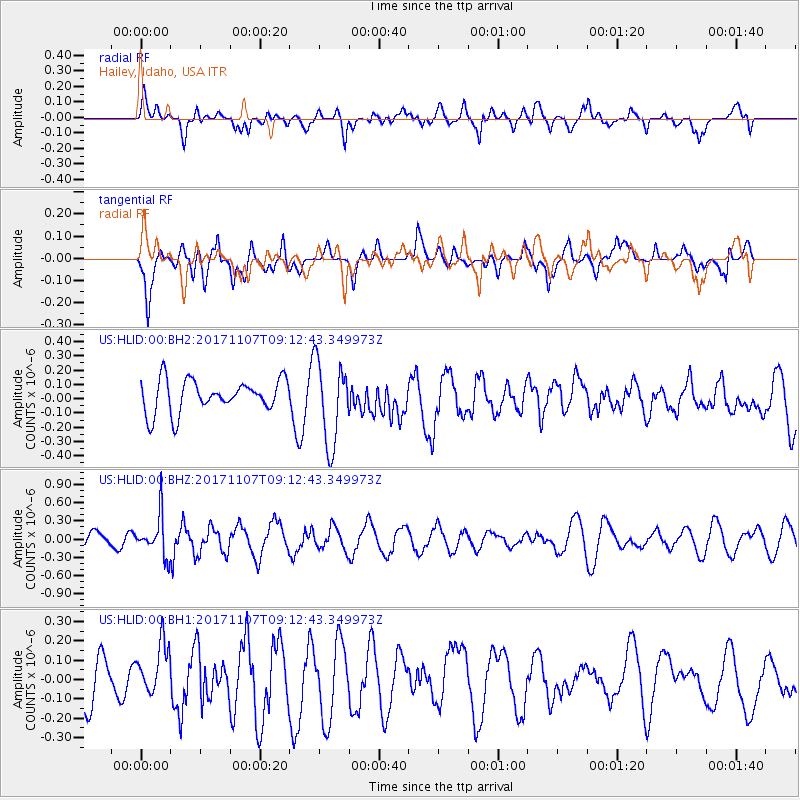
HLID Hailey, Idaho, USA - Earthquake Result Viewer
*The percent match for this event was below the threshold and hence no stack was calculated.
| Earthquake location: |
Fiji Islands Region |
| Earthquake latitude/longitude: |
-17.7/-178.5 |
| Earthquake time(UTC): |
2017/11/07 (311) 09:01:39 GMT |
| Earthquake Depth: |
555 km |
| Earthquake Magnitude: |
5.7 Mww |
| Earthquake Catalog/Contributor: |
NEIC PDE/us |
|
| Network: |
US United States National Seismic Network |
| Station: |
HLID Hailey, Idaho, USA |
| Lat/Lon: |
43.56 N/114.41 W |
| Elevation: |
1772 m |
|
| Distance: |
84.5 deg |
| Az: |
41.074 deg |
| Baz: |
239.506 deg |
| Ray Param: |
$rayparam |
*The percent match for this event was below the threshold and hence was not used in the summary stack. |
|
| Radial Match: |
52.128414 % |
| Radial Bump: |
400 |
| Transverse Match: |
59.027187 % |
| Transverse Bump: |
400 |
| SOD ConfigId: |
2429771 |
| Insert Time: |
2017-11-21 09:05:28.531 +0000 |
| GWidth: |
2.5 |
| Max Bumps: |
400 |
| Tol: |
0.001 |
|
Signal To Noise
| Channel | StoN | STA | LTA |
| US:HLID:00:BHZ:20171107T09:12:43.349973Z | 2.006715 | 3.3649877E-7 | 1.6768638E-7 |
| US:HLID:00:BH1:20171107T09:12:43.349973Z | 1.0701576 | 1.294657E-7 | 1.2097816E-7 |
| US:HLID:00:BH2:20171107T09:12:43.349973Z | 2.5722582 | 2.9164653E-7 | 1.1338151E-7 |
| Arrivals |
| Ps | |
| PpPs | |
| PsPs/PpSs | |


