You are here: Home > Network List > GS - US Geological Survey Networks Stations List
> Station DEC06 Boomer > Earthquake Result Viewer
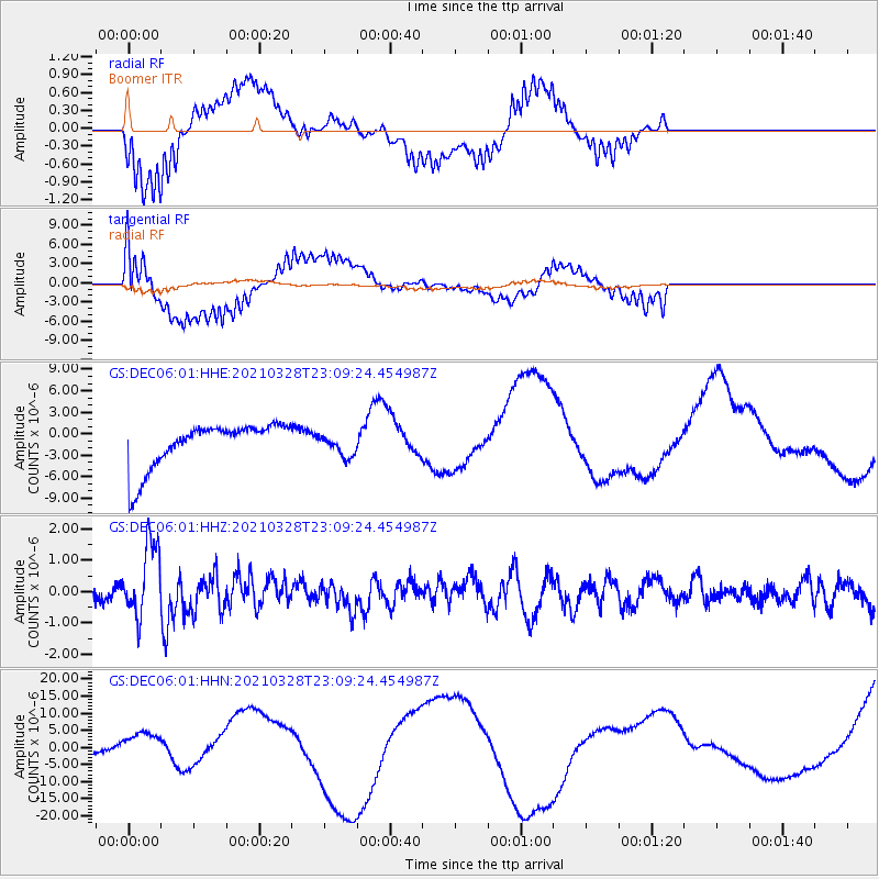
DEC06 Boomer - Earthquake Result Viewer
*The percent match for this event was below the threshold and hence no stack was calculated.
| Earthquake location: |
Northern Mid-Atlantic Ridge |
| Earthquake latitude/longitude: |
43.6/-28.8 |
| Earthquake time(UTC): |
2021/03/28 (087) 23:01:46 GMT |
| Earthquake Depth: |
10 km |
| Earthquake Magnitude: |
5.8 Mww |
| Earthquake Catalog/Contributor: |
NEIC PDE/us |
|
| Network: |
GS US Geological Survey Networks |
| Station: |
DEC06 Boomer |
| Lat/Lon: |
39.90 N/88.95 W |
| Elevation: |
215 m |
|
| Distance: |
44.2 deg |
| Az: |
286.727 deg |
| Baz: |
64.649 deg |
| Ray Param: |
$rayparam |
*The percent match for this event was below the threshold and hence was not used in the summary stack. |
|
| Radial Match: |
70.27416 % |
| Radial Bump: |
400 |
| Transverse Match: |
58.899487 % |
| Transverse Bump: |
336 |
| SOD ConfigId: |
24334971 |
| Insert Time: |
2021-04-11 23:15:31.328 +0000 |
| GWidth: |
2.5 |
| Max Bumps: |
400 |
| Tol: |
0.001 |
|
Signal To Noise
| Channel | StoN | STA | LTA |
| GS:DEC06:01:HHZ:20210328T23:09:24.454987Z | 4.823157 | 1.1454641E-6 | 2.374926E-7 |
| GS:DEC06:01:HHN:20210328T23:09:24.454987Z | 0.2701805 | 2.0060456E-6 | 7.4248355E-6 |
| GS:DEC06:01:HHE:20210328T23:09:24.454987Z | 0.44861853 | 1.4314036E-6 | 3.190692E-6 |
| Arrivals |
| Ps | |
| PpPs | |
| PsPs/PpSs | |


