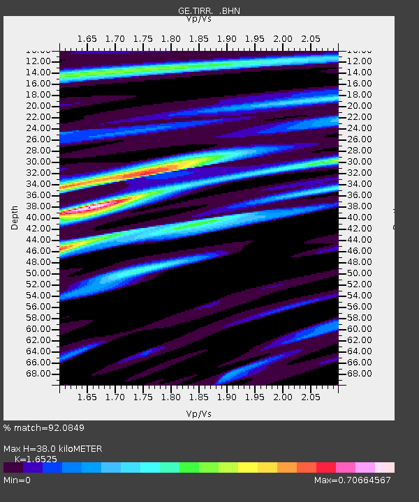
TIRR GEOFON Station Tirgusor, Romania - Earthquake Result Viewer

Earthquake location: Bonin Islands, Japan Region
Earthquake latitude/longitude: 27.0/142.6
Earthquake time(UTC): 2008/03/14 (074) 22:32:09 GMT
Earthquake Depth: 11 km
Earthquake Magnitude: 5.7 MB, 5.9 MS, 6.0 MW, 6.0 MW
Earthquake Catalog/Contributor: WHDF/NEIC
Network: GE GEOFON
Station: TIRR GEOFON Station Tirgusor, Romania
Lat/Lon: 44.46 N/28.41 E
Elevation: 77 m
Distance: 86.9 deg
Az: 319.142 deg
Baz: 54.604 deg
Ray Param: 0.043678258
Estimated Moho Depth: 38.0 km
Estimated Crust Vp/Vs: 1.65
Assumed Crust Vp: 6.12 km/s
Estimated Crust Vs: 3.703 km/s
Estimated Crust Poisson's Ratio: 0.21
Radial Match: 92.0849 %
Radial Bump: 400
Transverse Match: 75.22394 %
Transverse Bump: 400
SOD ConfigId: 2564
Insert Time: 2010-03-09 07:00:30.866 +0000
GWidth: 2.5
Max Bumps: 400
Tol: 0.001

Signal To Noise

ChannelStoNSTALTA
GE:TIRR: :BHN:20080314T22:44:22.990002Z1.79715851.2669054E-77.049492E-8
GE:TIRR: :BHE:20080314T22:44:22.979016Z2.83162522.2202057E-77.8407474E-8
GE:TIRR: :BHZ:20080314T22:44:22.990002Z4.9551335.7211753E-71.1545957E-7
Arrivals
Ps4.1 SECOND
PpPs16 SECOND
PsPs/PpSs20 SECOND