You are here: Home > Network List > NM - Cooperative New Madrid Seismic Network Stations List
> Station HDAR2 I40 Weigh Station,West Memphis,AR > Earthquake Result Viewer
HDAR2 I40 Weigh Station,West Memphis,AR - Earthquake Result Viewer
| Earthquake location: |
Northern Mid-Atlantic Ridge |
| Earthquake latitude/longitude: |
43.6/-28.8 |
| Earthquake time(UTC): |
2021/03/28 (087) 23:01:46 GMT |
| Earthquake Depth: |
10 km |
| Earthquake Magnitude: |
5.8 Mww |
| Earthquake Catalog/Contributor: |
NEIC PDE/us |
|
| Network: |
NM Cooperative New Madrid Seismic Network |
| Station: |
HDAR2 I40 Weigh Station,West Memphis,AR |
| Lat/Lon: |
35.15 N/90.09 W |
| Elevation: |
100 m |
|
| Distance: |
47.2 deg |
| Az: |
281.446 deg |
| Baz: |
60.262 deg |
| Ray Param: |
0.070173465 |
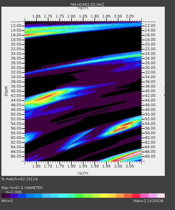
| Estimated Moho Depth: |
67.0 km |
| Estimated Crust Vp/Vs: |
2.07 |
| Assumed Crust Vp: |
6.273 km/s |
| Estimated Crust Vs: |
3.038 km/s |
| Estimated Crust Poisson's Ratio: |
0.35 |
|
| Radial Match: |
82.24116 % |
| Radial Bump: |
400 |
| Transverse Match: |
53.284508 % |
| Transverse Bump: |
387 |
| SOD ConfigId: |
24334971 |
| Insert Time: |
2021-04-11 23:21:13.658 +0000 |
| GWidth: |
2.5 |
| Max Bumps: |
400 |
| Tol: |
0.001 |
|

Signal To Noise
| Channel | StoN | STA | LTA |
| NM:HDAR2:00:HHZ:20210328T23:09:48.140015Z | 0.92581713 | 2.2467657E-6 | 2.4267922E-6 |
| NM:HDAR2:00:HHN:20210328T23:09:48.140015Z | 0.84252906 | 2.0683265E-6 | 2.454902E-6 |
| NM:HDAR2:00:HHE:20210328T23:09:48.140015Z | 1.0650713 | 2.125965E-6 | 1.9960776E-6 |
| Arrivals |
| Ps | 12 SECOND |
| PpPs | 31 SECOND |
| PsPs/PpSs | 43 SECOND |


