You are here: Home > Network List > GE - GEOFON Stations List
> Station TIRR GEOFON Station Tirgusor, Romania > Earthquake Result Viewer
TIRR GEOFON Station Tirgusor, Romania - Earthquake Result Viewer
| Earthquake location: |
Mariana Islands |
| Earthquake latitude/longitude: |
18.9/145.4 |
| Earthquake time(UTC): |
2007/10/31 (304) 03:30:17 GMT |
| Earthquake Depth: |
223 km |
| Earthquake Magnitude: |
6.2 MB, 7.2 MW, 7.2 MW |
| Earthquake Catalog/Contributor: |
WHDF/NEIC |
|
| Network: |
GE GEOFON |
| Station: |
TIRR GEOFON Station Tirgusor, Romania |
| Lat/Lon: |
44.46 N/28.41 E |
| Elevation: |
77 m |
|
| Distance: |
94.7 deg |
| Az: |
320.169 deg |
| Baz: |
57.87 deg |
| Ray Param: |
0.04078758 |
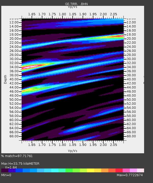
| Estimated Moho Depth: |
33.75 km |
| Estimated Crust Vp/Vs: |
1.64 |
| Assumed Crust Vp: |
6.12 km/s |
| Estimated Crust Vs: |
3.732 km/s |
| Estimated Crust Poisson's Ratio: |
0.20 |
|
| Radial Match: |
97.71761 % |
| Radial Bump: |
244 |
| Transverse Match: |
82.978966 % |
| Transverse Bump: |
400 |
| SOD ConfigId: |
2564 |
| Insert Time: |
2010-03-09 07:00:44.194 +0000 |
| GWidth: |
2.5 |
| Max Bumps: |
400 |
| Tol: |
0.001 |
|

Signal To Noise
| Channel | StoN | STA | LTA |
| GE:TIRR: :BHN:20071031T03:42:42.060024Z | 1.8414109 | 1.6188216E-7 | 8.791202E-8 |
| GE:TIRR: :BHE:20071031T03:42:42.060024Z | 3.6057215 | 3.9702186E-7 | 1.1010886E-7 |
| GE:TIRR: :BHZ:20071031T03:42:42.06802Z | 8.780629 | 1.0406229E-6 | 1.18513476E-7 |
| Arrivals |
| Ps | 3.6 SECOND |
| PpPs | 14 SECOND |
| PsPs/PpSs | 18 SECOND |


