You are here: Home > Network List > GE - GEOFON Stations List
> Station TIRR GEOFON Station Tirgusor, Romania > Earthquake Result Viewer
TIRR GEOFON Station Tirgusor, Romania - Earthquake Result Viewer
| Earthquake location: |
Java, Indonesia |
| Earthquake latitude/longitude: |
-5.9/107.7 |
| Earthquake time(UTC): |
2007/08/08 (220) 17:04:57 GMT |
| Earthquake Depth: |
291 km |
| Earthquake Magnitude: |
6.1 MB |
| Earthquake Catalog/Contributor: |
WHDF/NEIC |
|
| Network: |
GE GEOFON |
| Station: |
TIRR GEOFON Station Tirgusor, Romania |
| Lat/Lon: |
44.46 N/28.41 E |
| Elevation: |
77 m |
|
| Distance: |
86.5 deg |
| Az: |
315.178 deg |
| Baz: |
101.719 deg |
| Ray Param: |
0.043288097 |
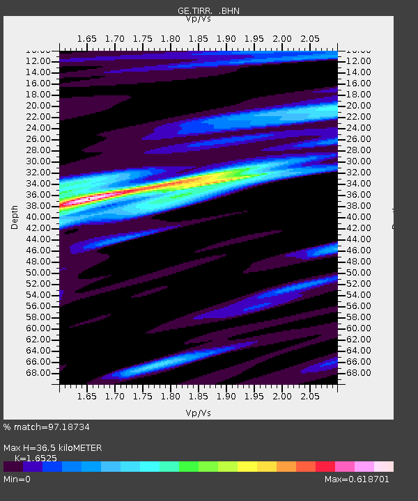
| Estimated Moho Depth: |
36.5 km |
| Estimated Crust Vp/Vs: |
1.65 |
| Assumed Crust Vp: |
6.12 km/s |
| Estimated Crust Vs: |
3.703 km/s |
| Estimated Crust Poisson's Ratio: |
0.21 |
|
| Radial Match: |
97.18734 % |
| Radial Bump: |
400 |
| Transverse Match: |
90.033775 % |
| Transverse Bump: |
400 |
| SOD ConfigId: |
2564 |
| Insert Time: |
2010-03-09 07:00:59.216 +0000 |
| GWidth: |
2.5 |
| Max Bumps: |
400 |
| Tol: |
0.001 |
|

Signal To Noise
| Channel | StoN | STA | LTA |
| GE:TIRR: :BHN:20070808T17:16:36.800022Z | 10.5540905 | 5.7957965E-7 | 5.4915166E-8 |
| GE:TIRR: :BHE:20070808T17:16:36.819004Z | 9.91809 | 1.9151407E-6 | 1.9309572E-7 |
| GE:TIRR: :BHZ:20070808T17:16:36.808018Z | 13.043307 | 5.483846E-6 | 4.2043368E-7 |
| Arrivals |
| Ps | 4.0 SECOND |
| PpPs | 15 SECOND |
| PsPs/PpSs | 19 SECOND |


