You are here: Home > Network List > GE - GEOFON Stations List
> Station TIRR GEOFON Station Tirgusor, Romania > Earthquake Result Viewer
TIRR GEOFON Station Tirgusor, Romania - Earthquake Result Viewer
| Earthquake location: |
Sea Of Japan |
| Earthquake latitude/longitude: |
36.8/134.9 |
| Earthquake time(UTC): |
2007/07/16 (197) 14:17:37 GMT |
| Earthquake Depth: |
350 km |
| Earthquake Magnitude: |
6.2 MB, 6.8 MW, 6.8 MW |
| Earthquake Catalog/Contributor: |
WHDF/NEIC |
|
| Network: |
GE GEOFON |
| Station: |
TIRR GEOFON Station Tirgusor, Romania |
| Lat/Lon: |
44.46 N/28.41 E |
| Elevation: |
77 m |
|
| Distance: |
75.3 deg |
| Az: |
314.758 deg |
| Baz: |
52.733 deg |
| Ray Param: |
0.05075652 |
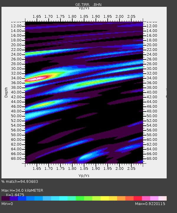
| Estimated Moho Depth: |
34.0 km |
| Estimated Crust Vp/Vs: |
1.65 |
| Assumed Crust Vp: |
6.12 km/s |
| Estimated Crust Vs: |
3.715 km/s |
| Estimated Crust Poisson's Ratio: |
0.21 |
|
| Radial Match: |
94.93683 % |
| Radial Bump: |
322 |
| Transverse Match: |
86.125824 % |
| Transverse Bump: |
400 |
| SOD ConfigId: |
2564 |
| Insert Time: |
2010-03-09 07:01:10.454 +0000 |
| GWidth: |
2.5 |
| Max Bumps: |
400 |
| Tol: |
0.001 |
|

Signal To Noise
| Channel | StoN | STA | LTA |
| GE:TIRR: :BHN:20070716T14:28:11.740024Z | 34.98364 | 1.1036562E-6 | 3.1547785E-8 |
| GE:TIRR: :BHE:20070716T14:28:11.769016Z | 29.717865 | 1.9030091E-6 | 6.4035866E-8 |
| GE:TIRR: :BHZ:20070716T14:28:11.780002Z | 139.43346 | 5.5707856E-6 | 3.9953E-8 |
| Arrivals |
| Ps | 3.7 SECOND |
| PpPs | 14 SECOND |
| PsPs/PpSs | 18 SECOND |


