You are here: Home > Network List > PF - Volcanologic Network of Piton de Fournaise-OVPF Stations List
> Station CIL Cilaos (Pompiers) > Earthquake Result Viewer
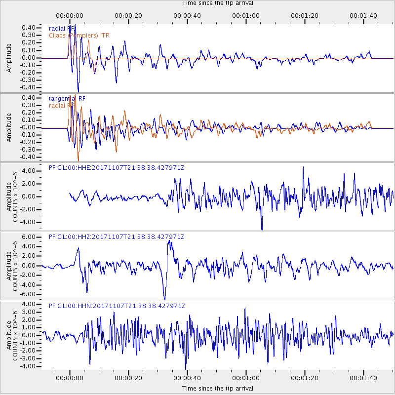
CIL Cilaos (Pompiers) - Earthquake Result Viewer
*The percent match for this event was below the threshold and hence no stack was calculated.
| Earthquake location: |
New Guinea, Papua New Guinea |
| Earthquake latitude/longitude: |
-4.2/143.5 |
| Earthquake time(UTC): |
2017/11/07 (311) 21:26:38 GMT |
| Earthquake Depth: |
107 km |
| Earthquake Magnitude: |
6.5 mww |
| Earthquake Catalog/Contributor: |
NEIC PDE/us |
|
| Network: |
PF Volcanologic Network of Piton de Fournaise-OVPF |
| Station: |
CIL Cilaos (Pompiers) |
| Lat/Lon: |
21.13 S/55.47 E |
| Elevation: |
1223 m |
|
| Distance: |
86.6 deg |
| Az: |
249.162 deg |
| Baz: |
93.212 deg |
| Ray Param: |
$rayparam |
*The percent match for this event was below the threshold and hence was not used in the summary stack. |
|
| Radial Match: |
81.58538 % |
| Radial Bump: |
400 |
| Transverse Match: |
75.4948 % |
| Transverse Bump: |
400 |
| SOD ConfigId: |
2429771 |
| Insert Time: |
2017-11-21 21:28:37.299 +0000 |
| GWidth: |
2.5 |
| Max Bumps: |
400 |
| Tol: |
0.001 |
|
Signal To Noise
| Channel | StoN | STA | LTA |
| PF:CIL:00:HHZ:20171107T21:38:38.427971Z | 5.0748844 | 1.7885354E-6 | 3.524288E-7 |
| PF:CIL:00:HHN:20171107T21:38:38.427971Z | 0.9546593 | 3.9197258E-7 | 4.1058897E-7 |
| PF:CIL:00:HHE:20171107T21:38:38.427971Z | 1.4040277 | 6.157823E-7 | 4.3858273E-7 |
| Arrivals |
| Ps | |
| PpPs | |
| PsPs/PpSs | |


