You are here: Home > Network List > TA - USArray Transportable Network (new EarthScope stations) Stations List
> Station I30M Mount Dempster, Yukon, CAN > Earthquake Result Viewer
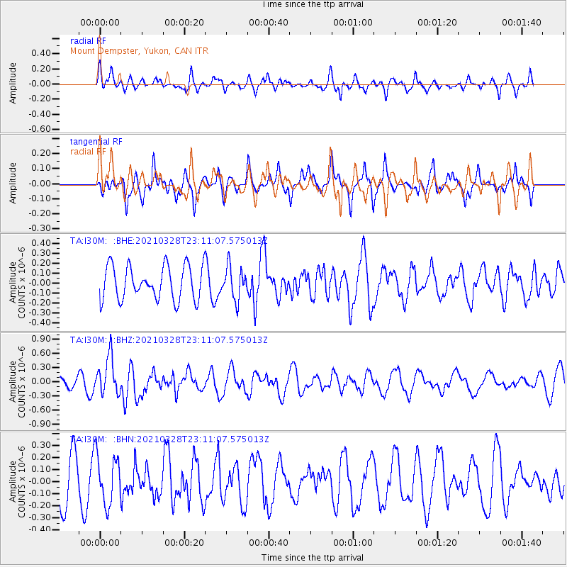
I30M Mount Dempster, Yukon, CAN - Earthquake Result Viewer
*The percent match for this event was below the threshold and hence no stack was calculated.
| Earthquake location: |
Northern Mid-Atlantic Ridge |
| Earthquake latitude/longitude: |
43.6/-28.8 |
| Earthquake time(UTC): |
2021/03/28 (087) 23:01:46 GMT |
| Earthquake Depth: |
10 km |
| Earthquake Magnitude: |
5.8 Mww |
| Earthquake Catalog/Contributor: |
NEIC PDE/us |
|
| Network: |
TA USArray Transportable Network (new EarthScope stations) |
| Station: |
I30M Mount Dempster, Yukon, CAN |
| Lat/Lon: |
65.22 N/136.38 W |
| Elevation: |
1399 m |
|
| Distance: |
57.9 deg |
| Az: |
331.697 deg |
| Baz: |
54.761 deg |
| Ray Param: |
$rayparam |
*The percent match for this event was below the threshold and hence was not used in the summary stack. |
|
| Radial Match: |
63.12355 % |
| Radial Bump: |
394 |
| Transverse Match: |
59.507805 % |
| Transverse Bump: |
334 |
| SOD ConfigId: |
24334971 |
| Insert Time: |
2021-04-11 23:28:31.363 +0000 |
| GWidth: |
2.5 |
| Max Bumps: |
400 |
| Tol: |
0.001 |
|
Signal To Noise
| Channel | StoN | STA | LTA |
| TA:I30M: :BHZ:20210328T23:11:07.575013Z | 4.038795 | 4.069137E-7 | 1.0075126E-7 |
| TA:I30M: :BHN:20210328T23:11:07.575013Z | 1.1976087 | 1.9482171E-7 | 1.6267559E-7 |
| TA:I30M: :BHE:20210328T23:11:07.575013Z | 0.97641337 | 1.6560344E-7 | 1.6960382E-7 |
| Arrivals |
| Ps | |
| PpPs | |
| PsPs/PpSs | |


